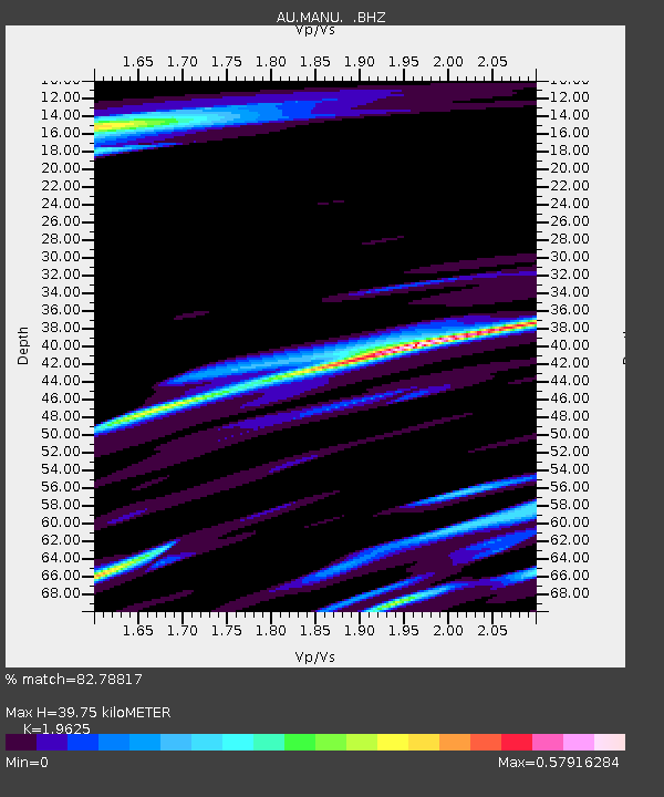
MANU Manus Island, Papau New Guinea - Earthquake Result Viewer

Earthquake location: Near West Coast Of Honshu, Japan
Earthquake latitude/longitude: 37.0/138.4
Earthquake time(UTC): 2011/03/11 (070) 18:59:16 GMT
Earthquake Depth: 9.3 km
Earthquake Magnitude: 6.1 MB, 6.1 MS, 6.3 MW, 6.2 MW
Earthquake Catalog/Contributor: WHDF/NEIC
Network: AU Australian Seismological Centre
Station: MANU Manus Island, Papau New Guinea
Lat/Lon: 2.04 S/147.37 E
Elevation: 142 m
Distance: 39.7 deg
Az: 165.863 deg
Baz: 348.719 deg
Ray Param: 0.07480696
Estimated Moho Depth: 39.75 km
Estimated Crust Vp/Vs: 1.96
Assumed Crust Vp: 4.082 km/s
Estimated Crust Vs: 2.08 km/s
Estimated Crust Poisson's Ratio: 0.32
Radial Match: 82.78817 %
Radial Bump: 266
Transverse Match: 57.956615 %
Transverse Bump: 400
SOD ConfigId: 356183
Insert Time: 2011-08-17 21:42:30.735 +0000
GWidth: 2.5
Max Bumps: 400
Tol: 0.001

Signal To Noise

ChannelStoNSTALTA
AU:MANU: :BHZ:20110311T19:06:18.520011Z5.28204151.442682E-62.7312961E-7
AU:MANU: :BHN:20110311T19:06:18.520011Z1.72488324.5226201E-72.6219863E-7
AU:MANU: :BHE:20110311T19:06:18.520011Z1.27774836.666244E-75.21718E-7
Arrivals
Ps9.6 SECOND
PpPs28 SECOND
PsPs/PpSs38 SECOND