You are here: Home > Network List > YB13 - Continental Dynamics/Cent. Anatolian Tectonics:Surface to Mantle Dynamics During Stations List
> Station AT28 Suleymanobasi,Gaziantep,Turkey > Earthquake Result Viewer
AT28 Suleymanobasi,Gaziantep,Turkey - Earthquake Result Viewer
| Earthquake location: |
North Atlantic Ocean |
| Earthquake latitude/longitude: |
14.7/-58.9 |
| Earthquake time(UTC): |
2014/02/18 (049) 09:27:13 GMT |
| Earthquake Depth: |
17 km |
| Earthquake Magnitude: |
6.5 MWW, 6.3 MWB, 6.5 MWC, 6.6 MWC, 6.7 MI |
| Earthquake Catalog/Contributor: |
NEIC PDE/NEIC COMCAT |
|
| Network: |
YB Continental Dynamics/Cent. Anatolian Tectonics:Surface to Mantle Dynamics During |
| Station: |
AT28 Suleymanobasi,Gaziantep,Turkey |
| Lat/Lon: |
37.25 N/37.55 E |
| Elevation: |
839 m |
|
| Distance: |
86.3 deg |
| Az: |
52.606 deg |
| Baz: |
285.482 deg |
| Ray Param: |
0.044130743 |
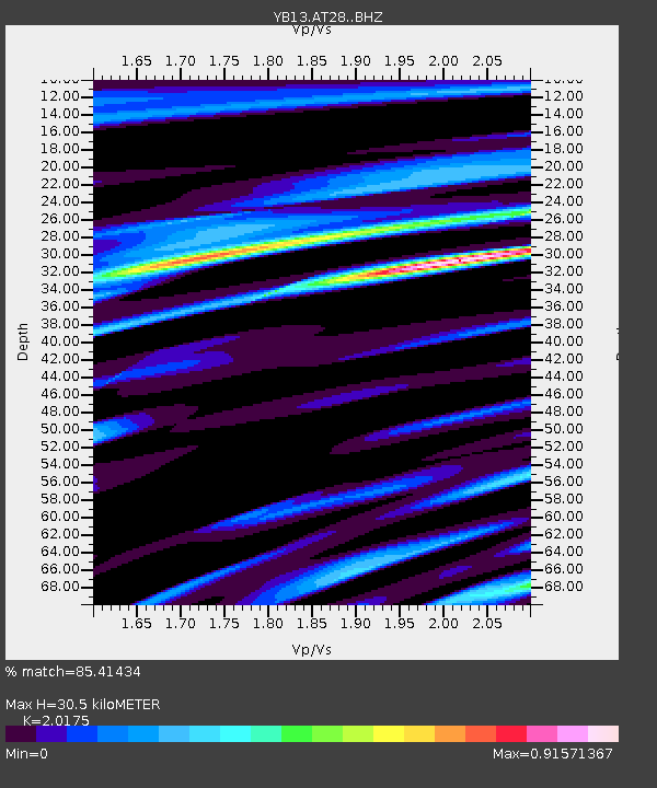
| Estimated Moho Depth: |
30.5 km |
| Estimated Crust Vp/Vs: |
2.02 |
| Assumed Crust Vp: |
6.247 km/s |
| Estimated Crust Vs: |
3.096 km/s |
| Estimated Crust Poisson's Ratio: |
0.34 |
|
| Radial Match: |
85.41434 % |
| Radial Bump: |
400 |
| Transverse Match: |
87.28583 % |
| Transverse Bump: |
400 |
| SOD ConfigId: |
3390531 |
| Insert Time: |
2019-04-10 09:16:06.716 +0000 |
| GWidth: |
2.5 |
| Max Bumps: |
400 |
| Tol: |
0.001 |
|

Signal To Noise
| Channel | StoN | STA | LTA |
| YB:AT28: :BHZ:20140218T09:39:23.040002Z | 23.60602 | 1.6757162E-6 | 7.098682E-8 |
| YB:AT28: :BHN:20140218T09:39:23.040002Z | 2.6142607 | 1.46082E-7 | 5.5878896E-8 |
| YB:AT28: :BHE:20140218T09:39:23.040002Z | 5.9876366 | 4.4839197E-7 | 7.488631E-8 |
| Arrivals |
| Ps | 5.1 SECOND |
| PpPs | 14 SECOND |
| PsPs/PpSs | 20 SECOND |


