You are here: Home > Network List > CI - Caltech Regional Seismic Network Stations List
> Station BEL Belle Mtn, Joshua Tree National Park, CA, USA > Earthquake Result Viewer
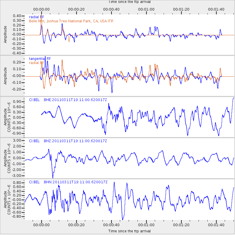
BEL Belle Mtn, Joshua Tree National Park, CA, USA - Earthquake Result Viewer
*The percent match for this event was below the threshold and hence no stack was calculated.
| Earthquake location: |
Near West Coast Of Honshu, Japan |
| Earthquake latitude/longitude: |
37.0/138.4 |
| Earthquake time(UTC): |
2011/03/11 (070) 18:59:16 GMT |
| Earthquake Depth: |
9.3 km |
| Earthquake Magnitude: |
6.1 MB, 6.1 MS, 6.3 MW, 6.2 MW |
| Earthquake Catalog/Contributor: |
WHDF/NEIC |
|
| Network: |
CI Caltech Regional Seismic Network |
| Station: |
BEL Belle Mtn, Joshua Tree National Park, CA, USA |
| Lat/Lon: |
34.00 N/116.00 W |
| Elevation: |
1388 m |
|
| Distance: |
81.1 deg |
| Az: |
54.076 deg |
| Baz: |
308.72 deg |
| Ray Param: |
$rayparam |
*The percent match for this event was below the threshold and hence was not used in the summary stack. |
|
| Radial Match: |
74.49392 % |
| Radial Bump: |
400 |
| Transverse Match: |
75.49685 % |
| Transverse Bump: |
400 |
| SOD ConfigId: |
356183 |
| Insert Time: |
2011-08-17 21:57:48.367 +0000 |
| GWidth: |
2.5 |
| Max Bumps: |
400 |
| Tol: |
0.001 |
|
Signal To Noise
| Channel | StoN | STA | LTA |
| CI:BEL: :BHZ:20110311T19:11:00.620017Z | 2.3914452 | 7.167195E-7 | 2.997014E-7 |
| CI:BEL: :BHN:20110311T19:11:00.620017Z | 1.1493322 | 3.08238E-7 | 2.6818876E-7 |
| CI:BEL: :BHE:20110311T19:11:00.620017Z | 0.7967752 | 2.2571348E-7 | 2.8328375E-7 |
| Arrivals |
| Ps | |
| PpPs | |
| PsPs/PpSs | |


