You are here: Home > Network List > YB13 - Continental Dynamics/Cent. Anatolian Tectonics:Surface to Mantle Dynamics During Stations List
> Station AT31 Inalli,Nevsehir,Turkey > Earthquake Result Viewer
AT31 Inalli,Nevsehir,Turkey - Earthquake Result Viewer
| Earthquake location: |
North Atlantic Ocean |
| Earthquake latitude/longitude: |
14.7/-58.9 |
| Earthquake time(UTC): |
2014/02/18 (049) 09:27:13 GMT |
| Earthquake Depth: |
17 km |
| Earthquake Magnitude: |
6.5 MWW, 6.3 MWB, 6.5 MWC, 6.6 MWC, 6.7 MI |
| Earthquake Catalog/Contributor: |
NEIC PDE/NEIC COMCAT |
|
| Network: |
YB Continental Dynamics/Cent. Anatolian Tectonics:Surface to Mantle Dynamics During |
| Station: |
AT31 Inalli,Nevsehir,Turkey |
| Lat/Lon: |
38.57 N/34.51 E |
| Elevation: |
1303 m |
|
| Distance: |
83.7 deg |
| Az: |
51.931 deg |
| Baz: |
283.562 deg |
| Ray Param: |
0.046024054 |
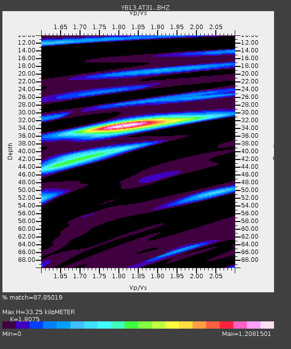
| Estimated Moho Depth: |
33.25 km |
| Estimated Crust Vp/Vs: |
1.81 |
| Assumed Crust Vp: |
6.35 km/s |
| Estimated Crust Vs: |
3.513 km/s |
| Estimated Crust Poisson's Ratio: |
0.28 |
|
| Radial Match: |
87.85019 % |
| Radial Bump: |
400 |
| Transverse Match: |
83.98461 % |
| Transverse Bump: |
400 |
| SOD ConfigId: |
3390531 |
| Insert Time: |
2019-04-10 09:16:08.452 +0000 |
| GWidth: |
2.5 |
| Max Bumps: |
400 |
| Tol: |
0.001 |
|

Signal To Noise
| Channel | StoN | STA | LTA |
| YB:AT31: :BHZ:20140218T09:39:09.759973Z | 12.600791 | 1.6545873E-6 | 1.3130821E-7 |
| YB:AT31: :BHN:20140218T09:39:09.759973Z | 1.5489119 | 1.9094611E-7 | 1.2327757E-7 |
| YB:AT31: :BHE:20140218T09:39:09.759973Z | 3.0748806 | 6.648235E-7 | 2.1621116E-7 |
| Arrivals |
| Ps | 4.3 SECOND |
| PpPs | 14 SECOND |
| PsPs/PpSs | 19 SECOND |


