You are here: Home > Network List > CI - Caltech Regional Seismic Network Stations List
> Station LGU LGU, Camarillo, CA, USA > Earthquake Result Viewer
LGU LGU, Camarillo, CA, USA - Earthquake Result Viewer
| Earthquake location: |
Near East Coast Of Kamchatka |
| Earthquake latitude/longitude: |
51.1/157.5 |
| Earthquake time(UTC): |
2006/08/24 (236) 21:50:36 GMT |
| Earthquake Depth: |
43 km |
| Earthquake Magnitude: |
5.9 MB, 6.2 MS, 6.5 MW, 6.5 MW |
| Earthquake Catalog/Contributor: |
WHDF/NEIC |
|
| Network: |
CI Caltech Regional Seismic Network |
| Station: |
LGU LGU, Camarillo, CA, USA |
| Lat/Lon: |
34.11 N/119.07 W |
| Elevation: |
416 m |
|
| Distance: |
60.4 deg |
| Az: |
71.384 deg |
| Baz: |
313.994 deg |
| Ray Param: |
0.061448693 |
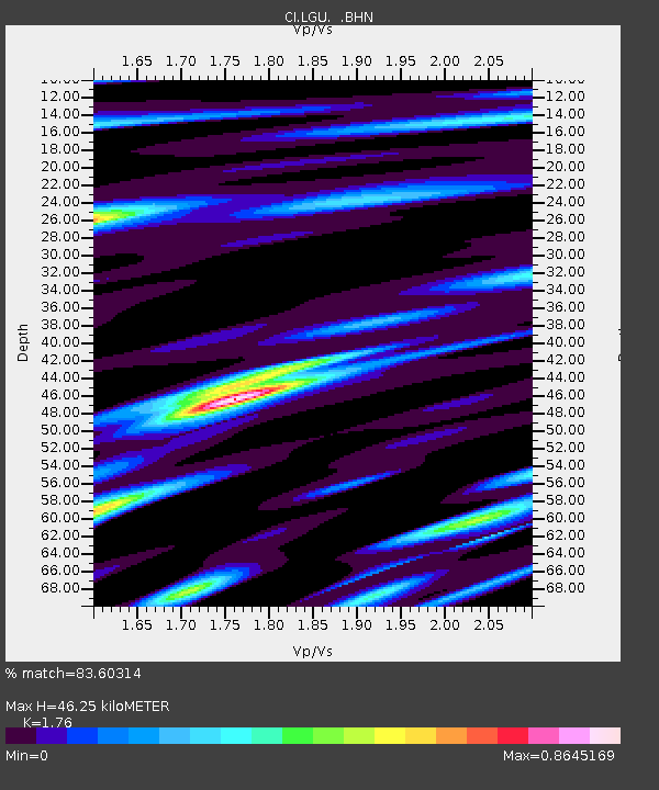
| Estimated Moho Depth: |
46.25 km |
| Estimated Crust Vp/Vs: |
1.76 |
| Assumed Crust Vp: |
6.1 km/s |
| Estimated Crust Vs: |
3.466 km/s |
| Estimated Crust Poisson's Ratio: |
0.26 |
|
| Radial Match: |
83.60314 % |
| Radial Bump: |
400 |
| Transverse Match: |
76.21327 % |
| Transverse Bump: |
400 |
| SOD ConfigId: |
2665 |
| Insert Time: |
2010-02-25 20:13:43.351 +0000 |
| GWidth: |
2.5 |
| Max Bumps: |
400 |
| Tol: |
0.001 |
|

Signal To Noise
| Channel | StoN | STA | LTA |
| CI:LGU: :BHN:20060824T22:00:11.074011Z | 3.3488262 | 9.877982E-7 | 2.9496852E-7 |
| CI:LGU: :BHE:20060824T22:00:11.074011Z | 2.7179174 | 5.14223E-7 | 1.8919744E-7 |
| CI:LGU: :BHZ:20060824T22:00:11.074011Z | 10.885626 | 1.992915E-6 | 1.8307767E-7 |
| Arrivals |
| Ps | 6.0 SECOND |
| PpPs | 20 SECOND |
| PsPs/PpSs | 26 SECOND |


