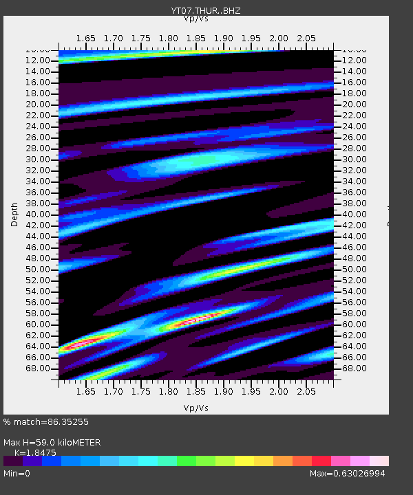
THUR THUR - Earthquake Result Viewer

Earthquake location: North Atlantic Ocean
Earthquake latitude/longitude: 14.7/-58.9
Earthquake time(UTC): 2014/02/18 (049) 09:27:13 GMT
Earthquake Depth: 17 km
Earthquake Magnitude: 6.5 MWW, 6.3 MWB, 6.5 MWC, 6.6 MWC, 6.7 MI
Earthquake Catalog/Contributor: NEIC PDE/NEIC COMCAT
Network: YT POLENET
Station: THUR THUR
Lat/Lon: 72.53 S/97.56 W
Elevation: 239 m
Distance: 90.6 deg
Az: 190.87 deg
Baz: 37.179 deg
Ray Param: 0.04165768
Estimated Moho Depth: 59.0 km
Estimated Crust Vp/Vs: 1.85
Assumed Crust Vp: 6.43 km/s
Estimated Crust Vs: 3.48 km/s
Estimated Crust Poisson's Ratio: 0.29
Radial Match: 86.35255 %
Radial Bump: 400
Transverse Match: 86.52081 %
Transverse Bump: 400
SOD ConfigId: 3390531
Insert Time: 2019-04-10 09:16:41.680 +0000
GWidth: 2.5
Max Bumps: 400
Tol: 0.001

Signal To Noise

ChannelStoNSTALTA
YT:THUR: :BHZ:20140218T09:39:42.925012Z16.861882.048706E-61.2149927E-7
YT:THUR: :BHN:20140218T09:39:42.925012Z3.8194375.820416E-71.5238936E-7
YT:THUR: :BHE:20140218T09:39:42.925012Z1.00570857.579698E-97.536675E-9
Arrivals
Ps7.9 SECOND
PpPs26 SECOND
PsPs/PpSs34 SECOND