K22A Casper, WY, USA - Earthquake Result Viewer
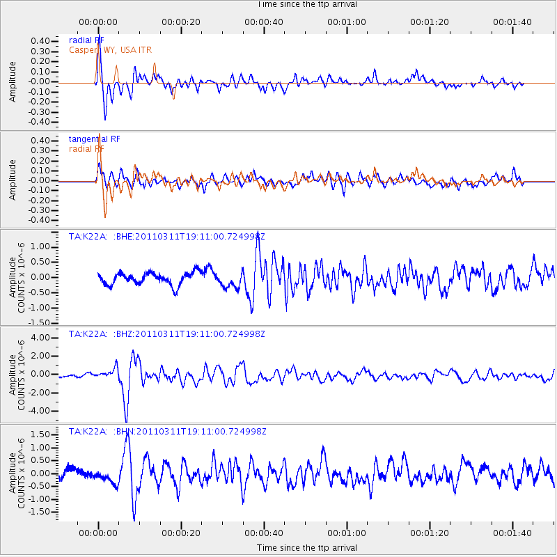
Earthquake location: Near West Coast Of Honshu, Japan
Earthquake latitude/longitude: 37.0/138.4
Earthquake time(UTC): 2011/03/11 (070) 18:59:16 GMT
Earthquake Depth: 9.3 km
Earthquake Magnitude: 6.1 MB, 6.1 MS, 6.3 MW, 6.2 MW
Earthquake Catalog/Contributor: WHDF/NEIC
Network: TA USArray Transportable Network (new EarthScope stations)
Station: K22A Casper, WY, USA
Lat/Lon: 42.65 N/106.52 W
Elevation: 1686 m
Distance: 81.1 deg
Az: 42.546 deg
Baz: 312.81 deg
Ray Param: 0.047802754
Estimated Moho Depth: 58.0 km
Estimated Crust Vp/Vs: 1.94
Assumed Crust Vp: 6.178 km/s
Estimated Crust Vs: 3.189 km/s
Estimated Crust Poisson's Ratio: 0.32
Radial Match: 86.66401 %
Radial Bump: 400
Transverse Match: 66.397545 %
Transverse Bump: 400
SOD ConfigId: 356183
Insert Time: 2011-08-17 22:27:54.089 +0000
GWidth: 2.5
Max Bumps: 400
Tol: 0.001

Signal To Noise

ChannelStoNSTALTA
TA:K22A: :BHZ:20110311T19:11:00.724998Z2.57908326.101665E-72.3658272E-7
TA:K22A: :BHN:20110311T19:11:00.724998Z1.36494032.6235406E-71.9220917E-7
TA:K22A: :BHE:20110311T19:11:00.724998Z1.30742282.616108E-72.0009658E-7
Arrivals
Ps9.0 SECOND
PpPs27 SECOND
PsPs/PpSs36 SECOND