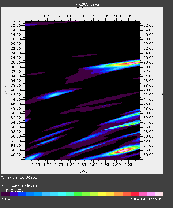
R29A Marienthal, KS, USA - Earthquake Result Viewer
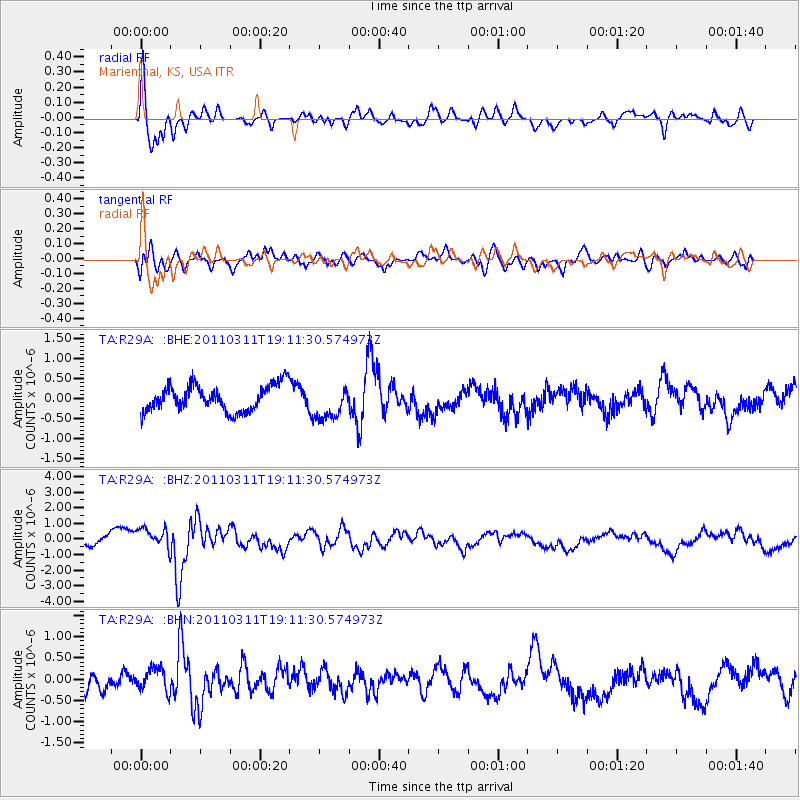
Earthquake location: Near West Coast Of Honshu, Japan
Earthquake latitude/longitude: 37.0/138.4
Earthquake time(UTC): 2011/03/11 (070) 18:59:16 GMT
Earthquake Depth: 9.3 km
Earthquake Magnitude: 6.1 MB, 6.1 MS, 6.3 MW, 6.2 MW
Earthquake Catalog/Contributor: WHDF/NEIC
Network: TA USArray Transportable Network (new EarthScope stations)
Station: R29A Marienthal, KS, USA
Lat/Lon: 38.42 N/101.14 W
Elevation: 957 m
Distance: 87.0 deg
Az: 42.671 deg
Baz: 316.314 deg
Ray Param: 0.04363022
Estimated Moho Depth: 66.0 km
Estimated Crust Vp/Vs: 2.02
Assumed Crust Vp: 6.483 km/s
Estimated Crust Vs: 3.205 km/s
Estimated Crust Poisson's Ratio: 0.34
Radial Match: 80.80255 %
Radial Bump: 400
Transverse Match: 54.79167 %
Transverse Bump: 400
SOD ConfigId: 356183
Insert Time: 2011-08-17 22:30:02.877 +0000
GWidth: 2.5
Max Bumps: 400
Tol: 0.001

Signal To Noise

ChannelStoNSTALTA
TA:R29A: :BHZ:20110311T19:11:30.574973Z1.77366337.844413E-74.422718E-7
TA:R29A: :BHN:20110311T19:11:30.574973Z1.29116862.800463E-72.1689367E-7
TA:R29A: :BHE:20110311T19:11:30.574973Z1.32844984.262339E-73.2085057E-7
Arrivals
Ps11 SECOND
PpPs30 SECOND
PsPs/PpSs41 SECOND