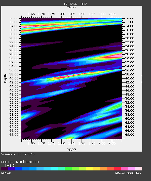
H26A Fairpoint, SD, USA - Earthquake Result Viewer

Earthquake location: Near West Coast Of Honshu, Japan
Earthquake latitude/longitude: 37.0/138.4
Earthquake time(UTC): 2011/03/11 (070) 18:59:16 GMT
Earthquake Depth: 9.3 km
Earthquake Magnitude: 6.1 MB, 6.1 MS, 6.3 MW, 6.2 MW
Earthquake Catalog/Contributor: WHDF/NEIC
Network: TA USArray Transportable Network (new EarthScope stations)
Station: H26A Fairpoint, SD, USA
Lat/Lon: 44.62 N/102.77 W
Elevation: 879 m
Distance: 81.7 deg
Az: 39.205 deg
Baz: 314.892 deg
Ray Param: 0.04737923
Estimated Moho Depth: 14.25 km
Estimated Crust Vp/Vs: 1.60
Assumed Crust Vp: 6.242 km/s
Estimated Crust Vs: 3.901 km/s
Estimated Crust Poisson's Ratio: 0.18
Radial Match: 85.525345 %
Radial Bump: 340
Transverse Match: 61.567818 %
Transverse Bump: 400
SOD ConfigId: 356183
Insert Time: 2011-08-17 22:36:03.217 +0000
GWidth: 2.5
Max Bumps: 400
Tol: 0.001

Signal To Noise

ChannelStoNSTALTA
TA:H26A: :BHZ:20110311T19:11:03.899985Z2.61718258.4883146E-73.2433027E-7
TA:H26A: :BHN:20110311T19:11:03.899985Z0.279170661.3928276E-74.989162E-7
TA:H26A: :BHE:20110311T19:11:03.899985Z0.87975184.5448775E-75.166091E-7
Arrivals
Ps1.4 SECOND
PpPs5.8 SECOND
PsPs/PpSs7.2 SECOND