You are here: Home > Network List > TA - USArray Transportable Network (new EarthScope stations) Stations List
> Station G26A Maurine, SD, USA > Earthquake Result Viewer
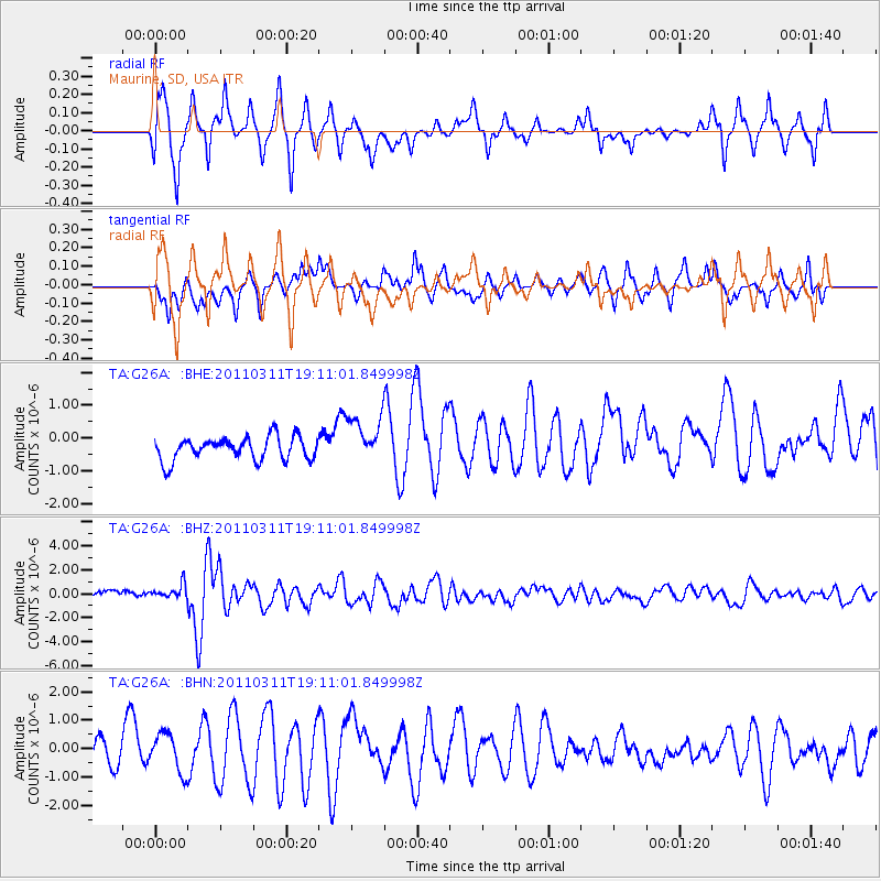
G26A Maurine, SD, USA - Earthquake Result Viewer
*The percent match for this event was below the threshold and hence no stack was calculated.
| Earthquake location: |
Near West Coast Of Honshu, Japan |
| Earthquake latitude/longitude: |
37.0/138.4 |
| Earthquake time(UTC): |
2011/03/11 (070) 18:59:16 GMT |
| Earthquake Depth: |
9.3 km |
| Earthquake Magnitude: |
6.1 MB, 6.1 MS, 6.3 MW, 6.2 MW |
| Earthquake Catalog/Contributor: |
WHDF/NEIC |
|
| Network: |
TA USArray Transportable Network (new EarthScope stations) |
| Station: |
G26A Maurine, SD, USA |
| Lat/Lon: |
45.29 N/102.60 W |
| Elevation: |
833 m |
|
| Distance: |
81.3 deg |
| Az: |
38.632 deg |
| Baz: |
314.931 deg |
| Ray Param: |
$rayparam |
*The percent match for this event was below the threshold and hence was not used in the summary stack. |
|
| Radial Match: |
78.30459 % |
| Radial Bump: |
394 |
| Transverse Match: |
60.34659 % |
| Transverse Bump: |
316 |
| SOD ConfigId: |
356183 |
| Insert Time: |
2011-08-17 22:36:46.348 +0000 |
| GWidth: |
2.5 |
| Max Bumps: |
400 |
| Tol: |
0.001 |
|
Signal To Noise
| Channel | StoN | STA | LTA |
| TA:G26A: :BHZ:20110311T19:11:01.849998Z | 1.8543755 | 6.4601136E-7 | 3.483714E-7 |
| TA:G26A: :BHN:20110311T19:11:01.849998Z | 1.5228275 | 6.826501E-7 | 4.4827806E-7 |
| TA:G26A: :BHE:20110311T19:11:01.849998Z | 2.067175 | 7.343319E-7 | 3.552345E-7 |
| Arrivals |
| Ps | |
| PpPs | |
| PsPs/PpSs | |


