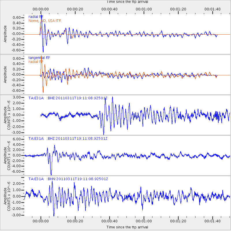
E31A Nome, ND, USA - Earthquake Result Viewer
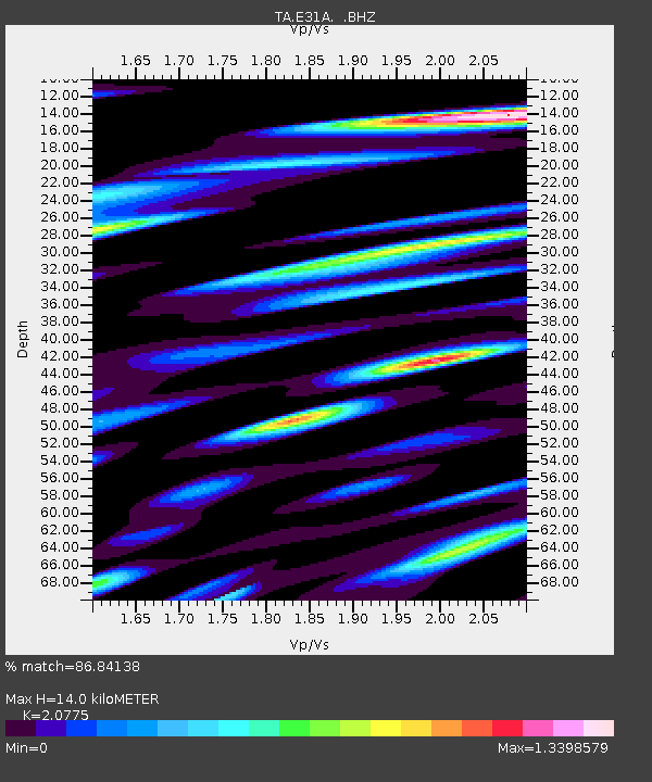
Earthquake location: Near West Coast Of Honshu, Japan
Earthquake latitude/longitude: 37.0/138.4
Earthquake time(UTC): 2011/03/11 (070) 18:59:16 GMT
Earthquake Depth: 9.3 km
Earthquake Magnitude: 6.1 MB, 6.1 MS, 6.3 MW, 6.2 MW
Earthquake Catalog/Contributor: WHDF/NEIC
Network: TA USArray Transportable Network (new EarthScope stations)
Station: E31A Nome, ND, USA
Lat/Lon: 46.56 N/97.89 W
Elevation: 427 m
Distance: 82.7 deg
Az: 35.348 deg
Baz: 317.849 deg
Ray Param: 0.046707947
Estimated Moho Depth: 14.0 km
Estimated Crust Vp/Vs: 2.08
Assumed Crust Vp: 6.498 km/s
Estimated Crust Vs: 3.128 km/s
Estimated Crust Poisson's Ratio: 0.35
Radial Match: 86.84138 %
Radial Bump: 400
Transverse Match: 73.86945 %
Transverse Bump: 400
SOD ConfigId: 356183
Insert Time: 2011-08-17 23:13:32.216 +0000
GWidth: 2.5
Max Bumps: 400
Tol: 0.001

Signal To Noise

ChannelStoNSTALTA
TA:E31A: :BHZ:20110311T19:11:08.92501Z3.77263931.1078453E-62.936526E-7
TA:E31A: :BHN:20110311T19:11:08.92501Z1.68976596.0366153E-73.5724568E-7
TA:E31A: :BHE:20110311T19:11:08.92501Z1.30132343.580174E-72.751179E-7
Arrivals
Ps2.4 SECOND
PpPs6.5 SECOND
PsPs/PpSs8.9 SECOND