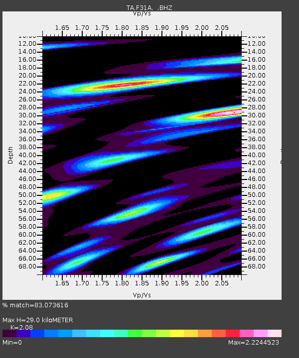
F31A Hecla, SD, USA - Earthquake Result Viewer
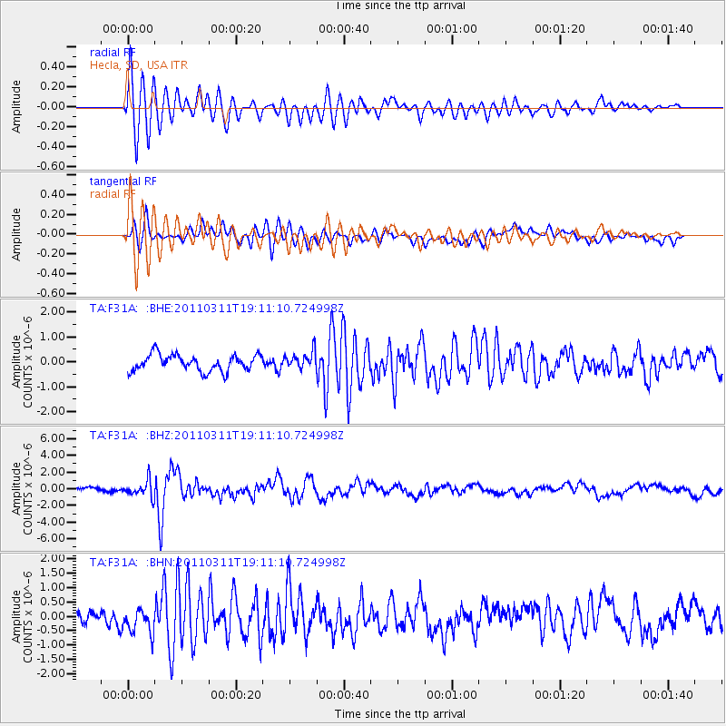
Earthquake location: Near West Coast Of Honshu, Japan
Earthquake latitude/longitude: 37.0/138.4
Earthquake time(UTC): 2011/03/11 (070) 18:59:16 GMT
Earthquake Depth: 9.3 km
Earthquake Magnitude: 6.1 MB, 6.1 MS, 6.3 MW, 6.2 MW
Earthquake Catalog/Contributor: WHDF/NEIC
Network: TA USArray Transportable Network (new EarthScope stations)
Station: F31A Hecla, SD, USA
Lat/Lon: 45.86 N/98.25 W
Elevation: 412 m
Distance: 83.0 deg
Az: 36.01 deg
Baz: 317.669 deg
Ray Param: 0.046466675
Estimated Moho Depth: 29.0 km
Estimated Crust Vp/Vs: 2.08
Assumed Crust Vp: 6.53 km/s
Estimated Crust Vs: 3.14 km/s
Estimated Crust Poisson's Ratio: 0.35
Radial Match: 83.073616 %
Radial Bump: 400
Transverse Match: 70.7329 %
Transverse Bump: 400
SOD ConfigId: 356183
Insert Time: 2011-08-17 23:17:07.293 +0000
GWidth: 2.5
Max Bumps: 400
Tol: 0.001

Signal To Noise

ChannelStoNSTALTA
TA:F31A: :BHZ:20110311T19:11:10.724998Z4.9821131.0022221E-62.0116407E-7
TA:F31A: :BHN:20110311T19:11:10.724998Z1.16466924.718825E-74.051644E-7
TA:F31A: :BHE:20110311T19:11:10.724998Z1.03851283.4063513E-73.2800278E-7
Arrivals
Ps4.9 SECOND
PpPs13 SECOND
PsPs/PpSs18 SECOND