You are here: Home > Network List > US - United States National Seismic Network Stations List
> Station SCIA State Center, Iowa, USA > Earthquake Result Viewer
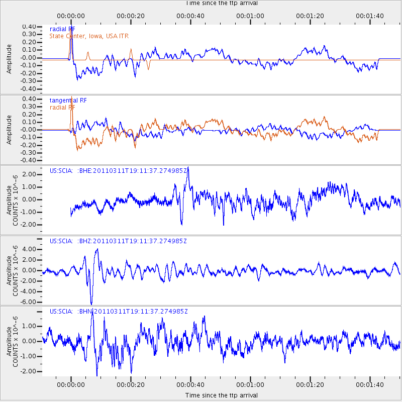
SCIA State Center, Iowa, USA - Earthquake Result Viewer
*The percent match for this event was below the threshold and hence no stack was calculated.
| Earthquake location: |
Near West Coast Of Honshu, Japan |
| Earthquake latitude/longitude: |
37.0/138.4 |
| Earthquake time(UTC): |
2011/03/11 (070) 18:59:16 GMT |
| Earthquake Depth: |
9.3 km |
| Earthquake Magnitude: |
6.1 MB, 6.1 MS, 6.3 MW, 6.2 MW |
| Earthquake Catalog/Contributor: |
WHDF/NEIC |
|
| Network: |
US United States National Seismic Network |
| Station: |
SCIA State Center, Iowa, USA |
| Lat/Lon: |
41.91 N/93.22 W |
| Elevation: |
312 m |
|
| Distance: |
88.4 deg |
| Az: |
35.813 deg |
| Baz: |
321.137 deg |
| Ray Param: |
$rayparam |
*The percent match for this event was below the threshold and hence was not used in the summary stack. |
|
| Radial Match: |
66.16795 % |
| Radial Bump: |
400 |
| Transverse Match: |
40.18956 % |
| Transverse Bump: |
400 |
| SOD ConfigId: |
356183 |
| Insert Time: |
2011-08-17 23:39:48.655 +0000 |
| GWidth: |
2.5 |
| Max Bumps: |
400 |
| Tol: |
0.001 |
|
Signal To Noise
| Channel | StoN | STA | LTA |
| US:SCIA: :BHZ:20110311T19:11:37.274985Z | 3.2254245 | 9.921165E-7 | 3.0759253E-7 |
| US:SCIA: :BHN:20110311T19:11:37.274985Z | 1.5779858 | 6.266816E-7 | 3.9714018E-7 |
| US:SCIA: :BHE:20110311T19:11:37.274985Z | 1.2744164 | 4.6068604E-7 | 3.6148782E-7 |
| Arrivals |
| Ps | |
| PpPs | |
| PsPs/PpSs | |


