You are here: Home > Network List > PR - Puerto Rico Seismic Network (PRSN) & Puerto Rico Strong Motion Program (PRSMP) Stations List
> Station OBIP Ponce, Puerto Rico(T4125) > Earthquake Result Viewer
OBIP Ponce, Puerto Rico(T4125) - Earthquake Result Viewer
| Earthquake location: |
Near Coast Of Peru |
| Earthquake latitude/longitude: |
-14.2/-75.6 |
| Earthquake time(UTC): |
2014/02/18 (049) 23:35:58 GMT |
| Earthquake Depth: |
57 km |
| Earthquake Magnitude: |
6.0 MWB, 5.9 MWW, 5.9 MWC, 6.0 MWC |
| Earthquake Catalog/Contributor: |
NEIC PDE/NEIC COMCAT |
|
| Network: |
PR Puerto Rico Seismic Network (PRSN) & Puerto Rico Strong Motion Program (PRSMP) |
| Station: |
OBIP Ponce, Puerto Rico(T4125) |
| Lat/Lon: |
18.04 N/66.61 W |
| Elevation: |
103 m |
|
| Distance: |
33.2 deg |
| Az: |
15.762 deg |
| Baz: |
196.078 deg |
| Ray Param: |
0.07818228 |
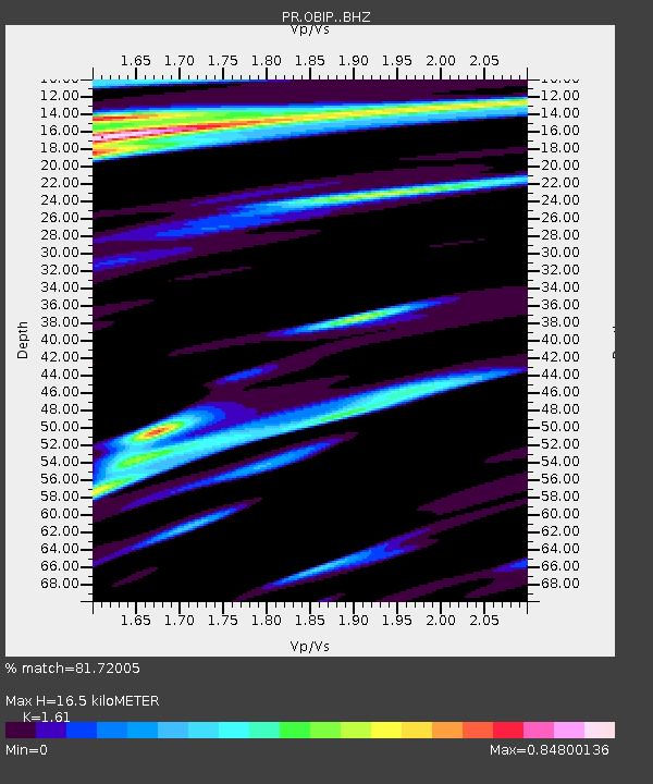
| Estimated Moho Depth: |
16.5 km |
| Estimated Crust Vp/Vs: |
1.61 |
| Assumed Crust Vp: |
5.14 km/s |
| Estimated Crust Vs: |
3.193 km/s |
| Estimated Crust Poisson's Ratio: |
0.19 |
|
| Radial Match: |
81.72005 % |
| Radial Bump: |
400 |
| Transverse Match: |
67.64269 % |
| Transverse Bump: |
400 |
| SOD ConfigId: |
3390531 |
| Insert Time: |
2019-04-10 09:24:02.376 +0000 |
| GWidth: |
2.5 |
| Max Bumps: |
400 |
| Tol: |
0.001 |
|

Signal To Noise
| Channel | StoN | STA | LTA |
| PR:OBIP: :BHZ:20140218T23:41:59.665007Z | 3.8758094 | 1.2099874E-6 | 3.121896E-7 |
| PR:OBIP: :BHN:20140218T23:41:59.665007Z | 1.6979085 | 5.943297E-7 | 3.5003634E-7 |
| PR:OBIP: :BHE:20140218T23:41:59.665007Z | 0.8518625 | 2.9544267E-7 | 3.468197E-7 |
| Arrivals |
| Ps | 2.1 SECOND |
| PpPs | 7.9 SECOND |
| PsPs/PpSs | 10 SECOND |


