You are here: Home > Network List > AZ - ANZA Regional Network Stations List
> Station PFO AZ.PFO > Earthquake Result Viewer
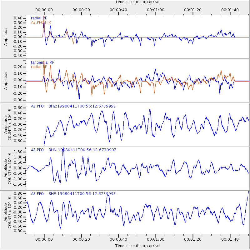
PFO AZ.PFO - Earthquake Result Viewer
*The percent match for this event was below the threshold and hence no stack was calculated.
| Earthquake location: |
South Of Fiji Islands |
| Earthquake latitude/longitude: |
-23.6/-176.1 |
| Earthquake time(UTC): |
1998/04/11 (101) 00:44:35 GMT |
| Earthquake Depth: |
33 km |
| Earthquake Magnitude: |
5.7 MB, 6.1 MS, 6.2 UNKNOWN, 6.1 MW |
| Earthquake Catalog/Contributor: |
WHDF/NEIC |
|
| Network: |
AZ ANZA Regional Network |
| Station: |
PFO AZ.PFO |
| Lat/Lon: |
33.61 N/116.46 W |
| Elevation: |
1259 m |
|
| Distance: |
80.4 deg |
| Az: |
46.922 deg |
| Baz: |
233.39 deg |
| Ray Param: |
$rayparam |
*The percent match for this event was below the threshold and hence was not used in the summary stack. |
|
| Radial Match: |
56.27553 % |
| Radial Bump: |
400 |
| Transverse Match: |
52.07603 % |
| Transverse Bump: |
400 |
| SOD ConfigId: |
4480 |
| Insert Time: |
2010-02-26 20:18:29.540 +0000 |
| GWidth: |
2.5 |
| Max Bumps: |
400 |
| Tol: |
0.001 |
|
Signal To Noise
| Channel | StoN | STA | LTA |
| AZ:PFO: :BHN:19980411T00:56:12.673999Z | 2.247365 | 4.5094717E-7 | 2.0065596E-7 |
| AZ:PFO: :BHE:19980411T00:56:12.673999Z | 0.96445835 | 3.2622918E-7 | 3.382512E-7 |
| AZ:PFO: :BHZ:19980411T00:56:12.673999Z | 1.5506489 | 3.4172743E-7 | 2.2037703E-7 |
| Arrivals |
| Ps | |
| PpPs | |
| PsPs/PpSs | |


