You are here: Home > Network List > TA - USArray Transportable Network (new EarthScope stations) Stations List
> Station 337A Centerville, TX, USA > Earthquake Result Viewer
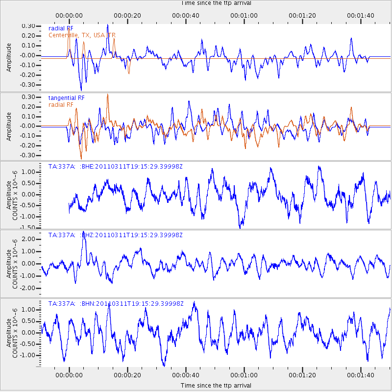
337A Centerville, TX, USA - Earthquake Result Viewer
*The percent match for this event was below the threshold and hence no stack was calculated.
| Earthquake location: |
Near East Coast Of Honshu, Japan |
| Earthquake latitude/longitude: |
39.3/142.9 |
| Earthquake time(UTC): |
2011/03/11 (070) 19:02:59 GMT |
| Earthquake Depth: |
27 km |
| Earthquake Magnitude: |
6.1 MB, 6.2 MS, 6.0 MW |
| Earthquake Catalog/Contributor: |
WHDF/NEIC |
|
| Network: |
TA USArray Transportable Network (new EarthScope stations) |
| Station: |
337A Centerville, TX, USA |
| Lat/Lon: |
31.32 N/95.89 W |
| Elevation: |
150 m |
|
| Distance: |
91.0 deg |
| Az: |
47.042 deg |
| Baz: |
318.463 deg |
| Ray Param: |
$rayparam |
*The percent match for this event was below the threshold and hence was not used in the summary stack. |
|
| Radial Match: |
61.999363 % |
| Radial Bump: |
400 |
| Transverse Match: |
62.585373 % |
| Transverse Bump: |
400 |
| SOD ConfigId: |
356183 |
| Insert Time: |
2011-08-18 01:54:59.292 +0000 |
| GWidth: |
2.5 |
| Max Bumps: |
400 |
| Tol: |
0.001 |
|
Signal To Noise
| Channel | StoN | STA | LTA |
| TA:337A: :BHZ:20110311T19:15:29.39998Z | 2.4059725 | 8.168394E-7 | 3.395049E-7 |
| TA:337A: :BHN:20110311T19:15:29.39998Z | 1.3263968 | 4.0081747E-7 | 3.0218519E-7 |
| TA:337A: :BHE:20110311T19:15:29.39998Z | 0.50400203 | 1.9173041E-7 | 3.8041594E-7 |
| Arrivals |
| Ps | |
| PpPs | |
| PsPs/PpSs | |


