You are here: Home > Network List > YT07 - POLENET Stations List
> Station HOWD HOWD > Earthquake Result Viewer
HOWD HOWD - Earthquake Result Viewer
| Earthquake location: |
Near Coast Of Peru |
| Earthquake latitude/longitude: |
-14.2/-75.6 |
| Earthquake time(UTC): |
2014/02/18 (049) 23:35:58 GMT |
| Earthquake Depth: |
57 km |
| Earthquake Magnitude: |
6.0 MWB, 5.9 MWW, 5.9 MWC, 6.0 MWC |
| Earthquake Catalog/Contributor: |
NEIC PDE/NEIC COMCAT |
|
| Network: |
YT POLENET |
| Station: |
HOWD HOWD |
| Lat/Lon: |
77.53 S/86.77 W |
| Elevation: |
1495 m |
|
| Distance: |
63.6 deg |
| Az: |
182.693 deg |
| Baz: |
12.104 deg |
| Ray Param: |
0.05932076 |
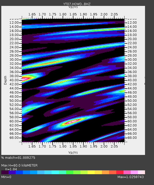
| Estimated Moho Depth: |
60.0 km |
| Estimated Crust Vp/Vs: |
1.84 |
| Assumed Crust Vp: |
6.047 km/s |
| Estimated Crust Vs: |
3.286 km/s |
| Estimated Crust Poisson's Ratio: |
0.29 |
|
| Radial Match: |
81.889275 % |
| Radial Bump: |
400 |
| Transverse Match: |
81.71733 % |
| Transverse Bump: |
400 |
| SOD ConfigId: |
3390531 |
| Insert Time: |
2019-04-10 09:27:15.318 +0000 |
| GWidth: |
2.5 |
| Max Bumps: |
400 |
| Tol: |
0.001 |
|

Signal To Noise
| Channel | StoN | STA | LTA |
| YT:HOWD: :BHZ:20140218T23:45:52.050017Z | 5.269534 | 1.096E-6 | 2.0798802E-7 |
| YT:HOWD: :BHN:20140218T23:45:52.050017Z | 4.0138445 | 6.4392486E-7 | 1.6042596E-7 |
| YT:HOWD: :BHE:20140218T23:45:52.050017Z | 1.7598739 | 2.8886137E-7 | 1.6413755E-7 |
| Arrivals |
| Ps | 8.6 SECOND |
| PpPs | 27 SECOND |
| PsPs/PpSs | 36 SECOND |


