You are here: Home > Network List > TA - USArray Transportable Network (new EarthScope stations) Stations List
> Station K32A Verdigre, NE, USA > Earthquake Result Viewer
K32A Verdigre, NE, USA - Earthquake Result Viewer
| Earthquake location: |
Near East Coast Of Honshu, Japan |
| Earthquake latitude/longitude: |
39.3/142.9 |
| Earthquake time(UTC): |
2011/03/11 (070) 19:02:59 GMT |
| Earthquake Depth: |
27 km |
| Earthquake Magnitude: |
6.1 MB, 6.2 MS, 6.0 MW |
| Earthquake Catalog/Contributor: |
WHDF/NEIC |
|
| Network: |
TA USArray Transportable Network (new EarthScope stations) |
| Station: |
K32A Verdigre, NE, USA |
| Lat/Lon: |
42.66 N/97.97 W |
| Elevation: |
512 m |
|
| Distance: |
81.5 deg |
| Az: |
40.642 deg |
| Baz: |
316.787 deg |
| Ray Param: |
0.04750276 |
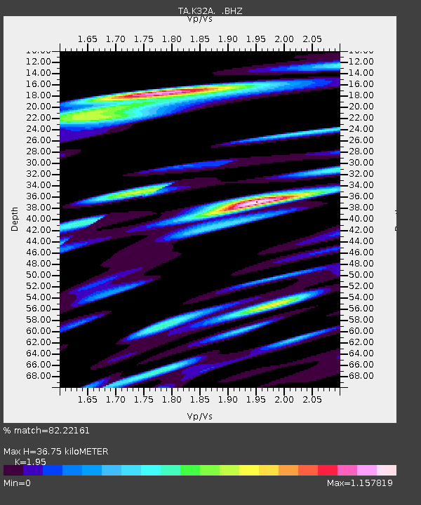
| Estimated Moho Depth: |
36.75 km |
| Estimated Crust Vp/Vs: |
1.95 |
| Assumed Crust Vp: |
6.498 km/s |
| Estimated Crust Vs: |
3.332 km/s |
| Estimated Crust Poisson's Ratio: |
0.32 |
|
| Radial Match: |
82.22161 % |
| Radial Bump: |
400 |
| Transverse Match: |
68.45015 % |
| Transverse Bump: |
400 |
| SOD ConfigId: |
356183 |
| Insert Time: |
2011-08-18 02:20:01.398 +0000 |
| GWidth: |
2.5 |
| Max Bumps: |
400 |
| Tol: |
0.001 |
|

Signal To Noise
| Channel | StoN | STA | LTA |
| TA:K32A: :BHZ:20110311T19:14:42.800005Z | 4.361178 | 1.7389718E-6 | 3.9873902E-7 |
| TA:K32A: :BHN:20110311T19:14:42.800005Z | 2.5077972 | 1.2133156E-6 | 4.8381725E-7 |
| TA:K32A: :BHE:20110311T19:14:42.800005Z | 2.1647956 | 1.0464412E-6 | 4.833903E-7 |
| Arrivals |
| Ps | 5.5 SECOND |
| PpPs | 16 SECOND |
| PsPs/PpSs | 22 SECOND |


