You are here: Home > Network List > TA - USArray Transportable Network (new EarthScope stations) Stations List
> Station J34A George, IA, USA > Earthquake Result Viewer
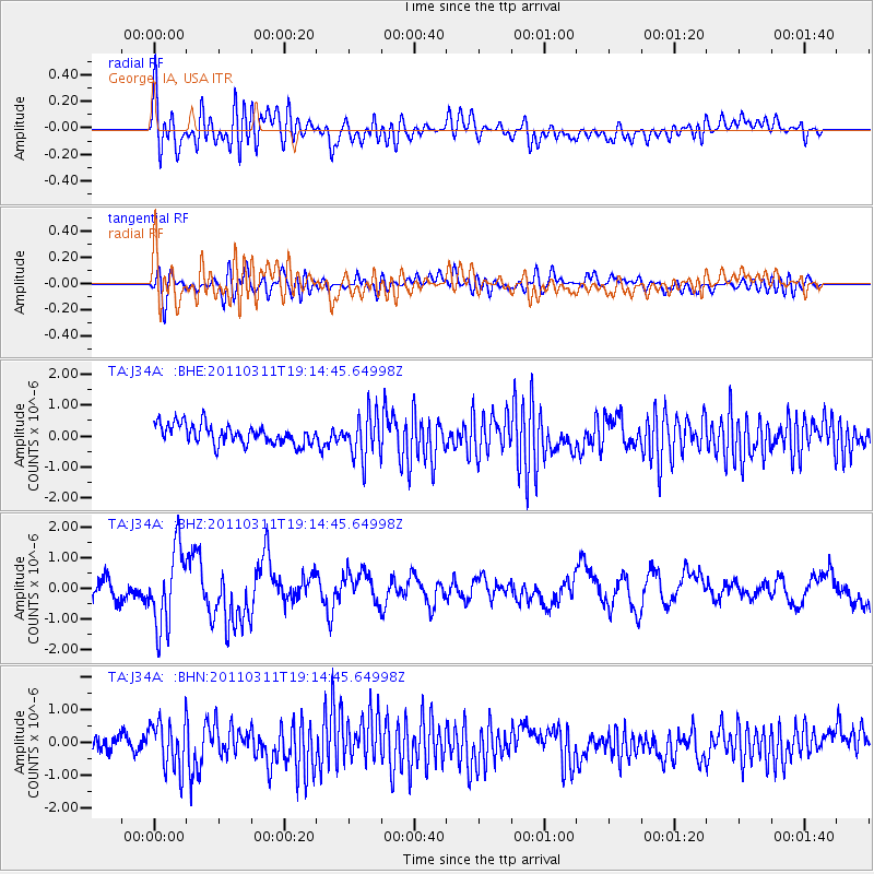
J34A George, IA, USA - Earthquake Result Viewer
*The percent match for this event was below the threshold and hence no stack was calculated.
| Earthquake location: |
Near East Coast Of Honshu, Japan |
| Earthquake latitude/longitude: |
39.3/142.9 |
| Earthquake time(UTC): |
2011/03/11 (070) 19:02:59 GMT |
| Earthquake Depth: |
27 km |
| Earthquake Magnitude: |
6.1 MB, 6.2 MS, 6.0 MW |
| Earthquake Catalog/Contributor: |
WHDF/NEIC |
|
| Network: |
TA USArray Transportable Network (new EarthScope stations) |
| Station: |
J34A George, IA, USA |
| Lat/Lon: |
43.28 N/95.96 W |
| Elevation: |
432 m |
|
| Distance: |
82.1 deg |
| Az: |
39.116 deg |
| Baz: |
317.937 deg |
| Ray Param: |
$rayparam |
*The percent match for this event was below the threshold and hence was not used in the summary stack. |
|
| Radial Match: |
67.36318 % |
| Radial Bump: |
400 |
| Transverse Match: |
67.15925 % |
| Transverse Bump: |
400 |
| SOD ConfigId: |
356183 |
| Insert Time: |
2011-08-18 02:23:30.422 +0000 |
| GWidth: |
2.5 |
| Max Bumps: |
400 |
| Tol: |
0.001 |
|
Signal To Noise
| Channel | StoN | STA | LTA |
| TA:J34A: :BHZ:20110311T19:14:45.64998Z | 3.793769 | 1.269389E-6 | 3.3459844E-7 |
| TA:J34A: :BHN:20110311T19:14:45.64998Z | 2.8766584 | 7.350251E-7 | 2.555135E-7 |
| TA:J34A: :BHE:20110311T19:14:45.64998Z | 2.2508264 | 7.1188254E-7 | 3.1627607E-7 |
| Arrivals |
| Ps | |
| PpPs | |
| PsPs/PpSs | |


