You are here: Home > Network List > TA - USArray Transportable Network (new EarthScope stations) Stations List
> Station J31A Geddes, SD, USA > Earthquake Result Viewer
J31A Geddes, SD, USA - Earthquake Result Viewer
| Earthquake location: |
Near East Coast Of Honshu, Japan |
| Earthquake latitude/longitude: |
39.3/142.9 |
| Earthquake time(UTC): |
2011/03/11 (070) 19:02:59 GMT |
| Earthquake Depth: |
27 km |
| Earthquake Magnitude: |
6.1 MB, 6.2 MS, 6.0 MW |
| Earthquake Catalog/Contributor: |
WHDF/NEIC |
|
| Network: |
TA USArray Transportable Network (new EarthScope stations) |
| Station: |
J31A Geddes, SD, USA |
| Lat/Lon: |
43.29 N/98.74 W |
| Elevation: |
491 m |
|
| Distance: |
80.7 deg |
| Az: |
40.616 deg |
| Baz: |
316.262 deg |
| Ray Param: |
0.04809034 |
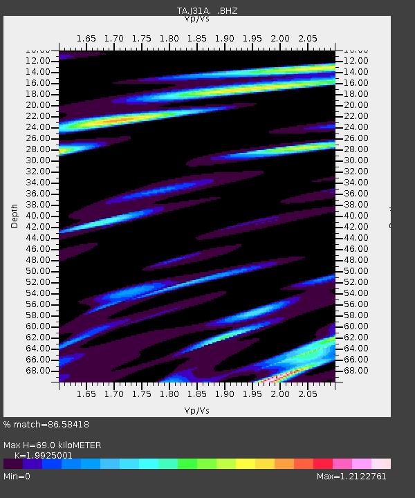
| Estimated Moho Depth: |
69.0 km |
| Estimated Crust Vp/Vs: |
1.99 |
| Assumed Crust Vp: |
6.53 km/s |
| Estimated Crust Vs: |
3.278 km/s |
| Estimated Crust Poisson's Ratio: |
0.33 |
|
| Radial Match: |
86.58418 % |
| Radial Bump: |
400 |
| Transverse Match: |
66.55177 % |
| Transverse Bump: |
400 |
| SOD ConfigId: |
356183 |
| Insert Time: |
2011-08-18 02:24:16.022 +0000 |
| GWidth: |
2.5 |
| Max Bumps: |
400 |
| Tol: |
0.001 |
|
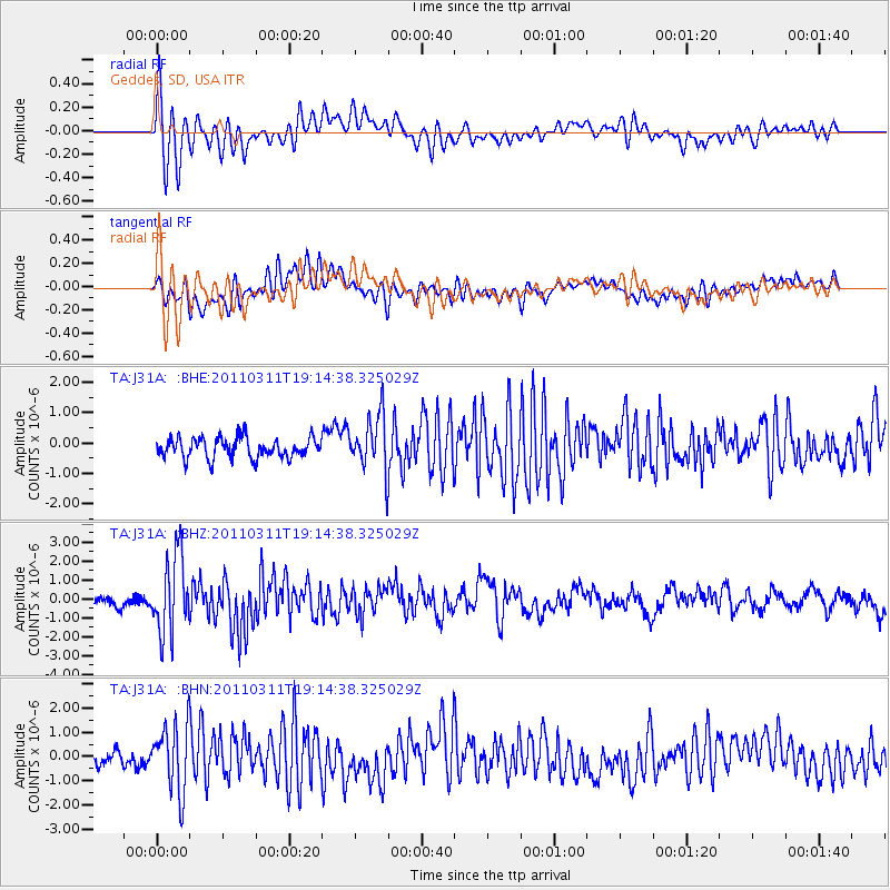
Signal To Noise
| Channel | StoN | STA | LTA |
| TA:J31A: :BHZ:20110311T19:14:38.325029Z | 4.909026 | 2.0716507E-6 | 4.2200847E-7 |
| TA:J31A: :BHN:20110311T19:14:38.325029Z | 3.3394396 | 1.3896648E-6 | 4.1613708E-7 |
| TA:J31A: :BHE:20110311T19:14:38.325029Z | 2.8394969 | 9.3601824E-7 | 3.296423E-7 |
| Arrivals |
| Ps | 11 SECOND |
| PpPs | 31 SECOND |
| PsPs/PpSs | 42 SECOND |


