You are here: Home > Network List > TA - USArray Transportable Network (new EarthScope stations) Stations List
> Station 142A Monroe, LA, USA > Earthquake Result Viewer
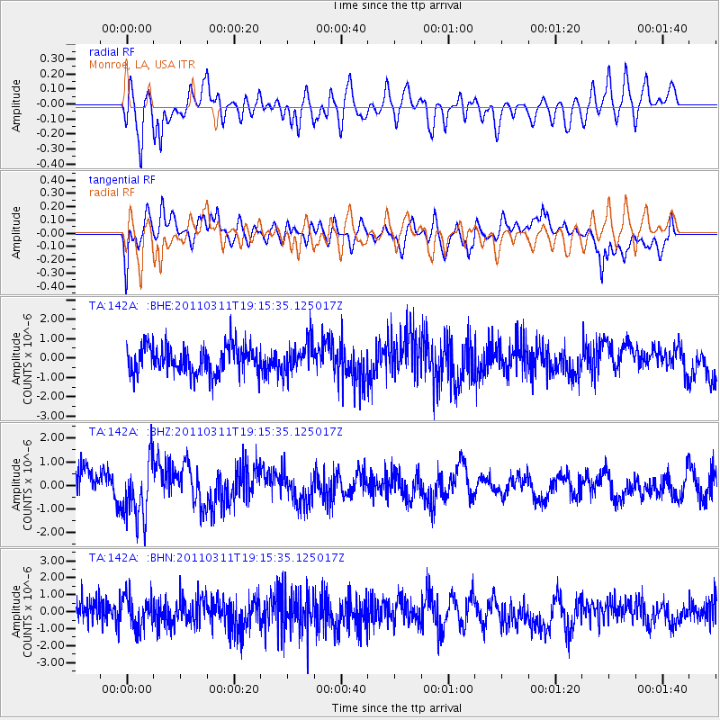
142A Monroe, LA, USA - Earthquake Result Viewer
*The percent match for this event was below the threshold and hence no stack was calculated.
| Earthquake location: |
Near East Coast Of Honshu, Japan |
| Earthquake latitude/longitude: |
39.3/142.9 |
| Earthquake time(UTC): |
2011/03/11 (070) 19:02:59 GMT |
| Earthquake Depth: |
27 km |
| Earthquake Magnitude: |
6.1 MB, 6.2 MS, 6.0 MW |
| Earthquake Catalog/Contributor: |
WHDF/NEIC |
|
| Network: |
TA USArray Transportable Network (new EarthScope stations) |
| Station: |
142A Monroe, LA, USA |
| Lat/Lon: |
32.55 N/91.95 W |
| Elevation: |
23 m |
|
| Distance: |
92.3 deg |
| Az: |
43.695 deg |
| Baz: |
320.633 deg |
| Ray Param: |
$rayparam |
*The percent match for this event was below the threshold and hence was not used in the summary stack. |
|
| Radial Match: |
63.93583 % |
| Radial Bump: |
400 |
| Transverse Match: |
57.154667 % |
| Transverse Bump: |
400 |
| SOD ConfigId: |
356183 |
| Insert Time: |
2011-08-18 03:02:30.160 +0000 |
| GWidth: |
2.5 |
| Max Bumps: |
400 |
| Tol: |
0.001 |
|
Signal To Noise
| Channel | StoN | STA | LTA |
| TA:142A: :BHZ:20110311T19:15:35.125017Z | 2.3613029 | 1.2389955E-6 | 5.247084E-7 |
| TA:142A: :BHN:20110311T19:15:35.125017Z | 1.336009 | 9.437544E-7 | 7.063982E-7 |
| TA:142A: :BHE:20110311T19:15:35.125017Z | 1.1612304 | 8.2577935E-7 | 7.1112447E-7 |
| Arrivals |
| Ps | |
| PpPs | |
| PsPs/PpSs | |


