You are here: Home > Network List > US - United States National Seismic Network Stations List
> Station WMOK Wichita Mountains, Oklahoma, USA > Earthquake Result Viewer
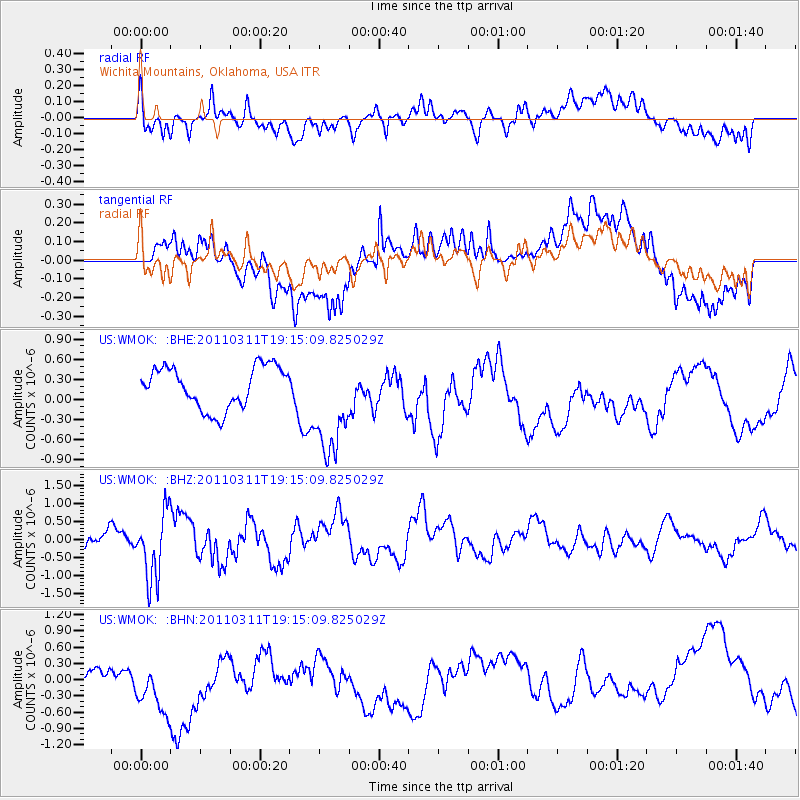
WMOK Wichita Mountains, Oklahoma, USA - Earthquake Result Viewer
*The percent match for this event was below the threshold and hence no stack was calculated.
| Earthquake location: |
Near East Coast Of Honshu, Japan |
| Earthquake latitude/longitude: |
39.3/142.9 |
| Earthquake time(UTC): |
2011/03/11 (070) 19:02:59 GMT |
| Earthquake Depth: |
27 km |
| Earthquake Magnitude: |
6.1 MB, 6.2 MS, 6.0 MW |
| Earthquake Catalog/Contributor: |
WHDF/NEIC |
|
| Network: |
US United States National Seismic Network |
| Station: |
WMOK Wichita Mountains, Oklahoma, USA |
| Lat/Lon: |
34.74 N/98.78 W |
| Elevation: |
486 m |
|
| Distance: |
86.9 deg |
| Az: |
46.543 deg |
| Baz: |
316.882 deg |
| Ray Param: |
$rayparam |
*The percent match for this event was below the threshold and hence was not used in the summary stack. |
|
| Radial Match: |
48.719696 % |
| Radial Bump: |
400 |
| Transverse Match: |
49.68494 % |
| Transverse Bump: |
400 |
| SOD ConfigId: |
356183 |
| Insert Time: |
2011-08-18 03:05:52.344 +0000 |
| GWidth: |
2.5 |
| Max Bumps: |
400 |
| Tol: |
0.001 |
|
Signal To Noise
| Channel | StoN | STA | LTA |
| US:WMOK: :BHZ:20110311T19:15:09.825029Z | 3.7528846 | 9.238431E-7 | 2.461688E-7 |
| US:WMOK: :BHN:20110311T19:15:09.825029Z | 1.6938194 | 6.940517E-7 | 4.0975542E-7 |
| US:WMOK: :BHE:20110311T19:15:09.825029Z | 2.5282927 | 7.843694E-7 | 3.1023677E-7 |
| Arrivals |
| Ps | |
| PpPs | |
| PsPs/PpSs | |


