You are here: Home > Network List > US - United States National Seismic Network Stations List
> Station DUG Dugway, Tooele County, Utah, USA > Earthquake Result Viewer
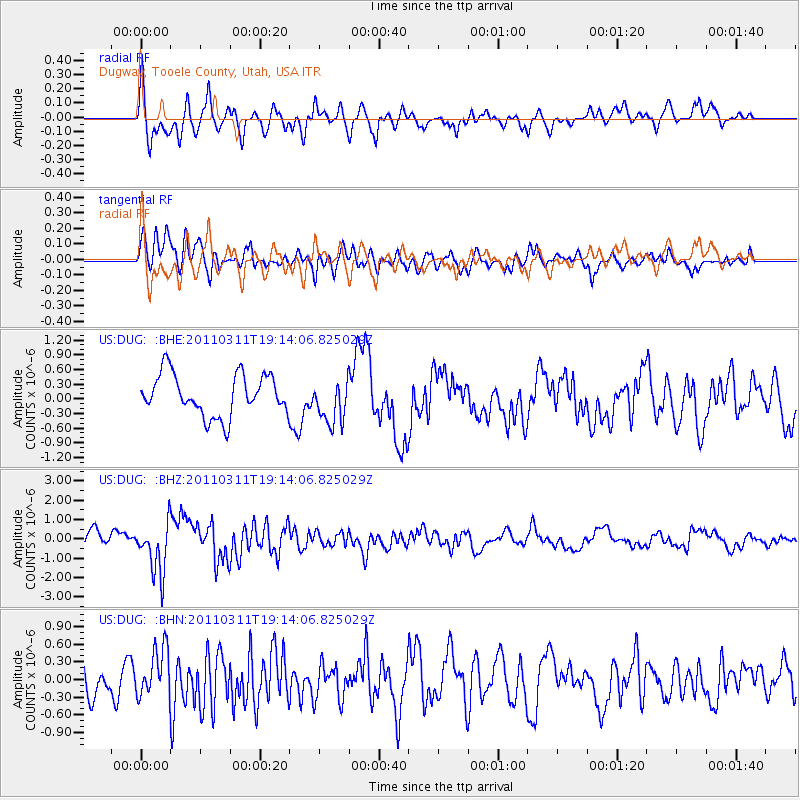
DUG Dugway, Tooele County, Utah, USA - Earthquake Result Viewer
*The percent match for this event was below the threshold and hence no stack was calculated.
| Earthquake location: |
Near East Coast Of Honshu, Japan |
| Earthquake latitude/longitude: |
39.3/142.9 |
| Earthquake time(UTC): |
2011/03/11 (070) 19:02:59 GMT |
| Earthquake Depth: |
27 km |
| Earthquake Magnitude: |
6.1 MB, 6.2 MS, 6.0 MW |
| Earthquake Catalog/Contributor: |
WHDF/NEIC |
|
| Network: |
US United States National Seismic Network |
| Station: |
DUG Dugway, Tooele County, Utah, USA |
| Lat/Lon: |
40.19 N/112.81 W |
| Elevation: |
1477 m |
|
| Distance: |
75.0 deg |
| Az: |
50.213 deg |
| Baz: |
308.928 deg |
| Ray Param: |
$rayparam |
*The percent match for this event was below the threshold and hence was not used in the summary stack. |
|
| Radial Match: |
75.46237 % |
| Radial Bump: |
400 |
| Transverse Match: |
61.741432 % |
| Transverse Bump: |
400 |
| SOD ConfigId: |
356183 |
| Insert Time: |
2011-08-18 03:06:12.931 +0000 |
| GWidth: |
2.5 |
| Max Bumps: |
400 |
| Tol: |
0.001 |
|
Signal To Noise
| Channel | StoN | STA | LTA |
| US:DUG: :BHZ:20110311T19:14:06.825029Z | 2.873074 | 1.3265669E-6 | 4.617239E-7 |
| US:DUG: :BHN:20110311T19:14:06.825029Z | 1.6893054 | 4.151511E-7 | 2.4575255E-7 |
| US:DUG: :BHE:20110311T19:14:06.825029Z | 1.0789491 | 4.5465043E-7 | 4.2138262E-7 |
| Arrivals |
| Ps | |
| PpPs | |
| PsPs/PpSs | |


