You are here: Home > Network List > US - United States National Seismic Network Stations List
> Station HAWA Hanford, Washington, USA > Earthquake Result Viewer
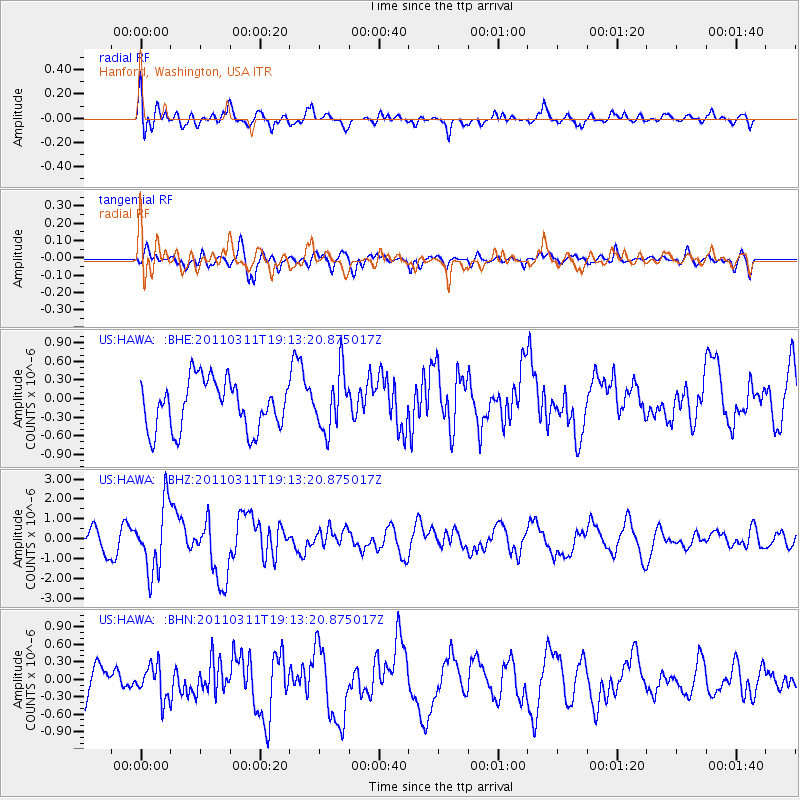
HAWA Hanford, Washington, USA - Earthquake Result Viewer
*The percent match for this event was below the threshold and hence no stack was calculated.
| Earthquake location: |
Near East Coast Of Honshu, Japan |
| Earthquake latitude/longitude: |
39.3/142.9 |
| Earthquake time(UTC): |
2011/03/11 (070) 19:02:59 GMT |
| Earthquake Depth: |
27 km |
| Earthquake Magnitude: |
6.1 MB, 6.2 MS, 6.0 MW |
| Earthquake Catalog/Contributor: |
WHDF/NEIC |
|
| Network: |
US United States National Seismic Network |
| Station: |
HAWA Hanford, Washington, USA |
| Lat/Lon: |
46.39 N/119.53 W |
| Elevation: |
364 m |
|
| Distance: |
67.4 deg |
| Az: |
48.013 deg |
| Baz: |
303.616 deg |
| Ray Param: |
$rayparam |
*The percent match for this event was below the threshold and hence was not used in the summary stack. |
|
| Radial Match: |
61.617085 % |
| Radial Bump: |
400 |
| Transverse Match: |
54.32057 % |
| Transverse Bump: |
400 |
| SOD ConfigId: |
356183 |
| Insert Time: |
2011-08-18 03:12:29.401 +0000 |
| GWidth: |
2.5 |
| Max Bumps: |
400 |
| Tol: |
0.001 |
|
Signal To Noise
| Channel | StoN | STA | LTA |
| US:HAWA: :BHZ:20110311T19:13:20.875017Z | 3.2027893 | 1.6915914E-6 | 5.2816193E-7 |
| US:HAWA: :BHN:20110311T19:13:20.875017Z | 1.108773 | 2.8945973E-7 | 2.6106312E-7 |
| US:HAWA: :BHE:20110311T19:13:20.875017Z | 1.1664721 | 4.6163882E-7 | 3.9575642E-7 |
| Arrivals |
| Ps | |
| PpPs | |
| PsPs/PpSs | |


