You are here: Home > Network List > TA - USArray Transportable Network (new EarthScope stations) Stations List
> Station O30A M W Ranch, Wilsonville, NE, USA > Earthquake Result Viewer
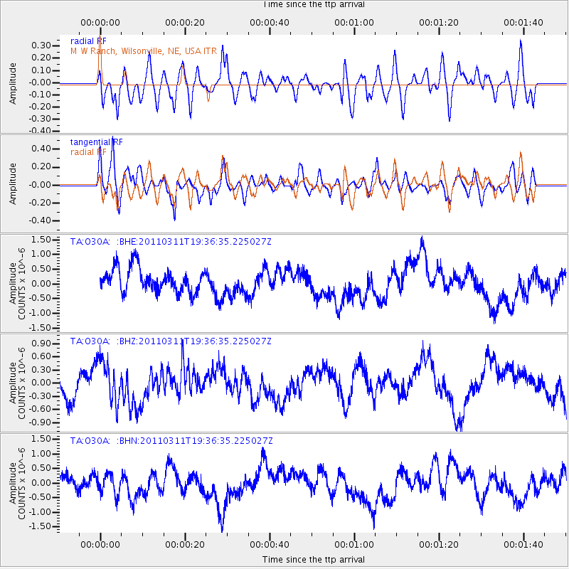
O30A M W Ranch, Wilsonville, NE, USA - Earthquake Result Viewer
*The percent match for this event was below the threshold and hence no stack was calculated.
| Earthquake location: |
Near East Coast Of Honshu, Japan |
| Earthquake latitude/longitude: |
35.7/140.7 |
| Earthquake time(UTC): |
2011/03/11 (070) 19:24:24 GMT |
| Earthquake Depth: |
2.2 km |
| Earthquake Magnitude: |
5.5 MB |
| Earthquake Catalog/Contributor: |
WHDF/NEIC |
|
| Network: |
TA USArray Transportable Network (new EarthScope stations) |
| Station: |
O30A M W Ranch, Wilsonville, NE, USA |
| Lat/Lon: |
40.18 N/100.06 W |
| Elevation: |
751 m |
|
| Distance: |
86.1 deg |
| Az: |
42.052 deg |
| Baz: |
314.627 deg |
| Ray Param: |
$rayparam |
*The percent match for this event was below the threshold and hence was not used in the summary stack. |
|
| Radial Match: |
56.242397 % |
| Radial Bump: |
400 |
| Transverse Match: |
51.603275 % |
| Transverse Bump: |
400 |
| SOD ConfigId: |
356183 |
| Insert Time: |
2011-08-18 05:45:22.281 +0000 |
| GWidth: |
2.5 |
| Max Bumps: |
400 |
| Tol: |
0.001 |
|
Signal To Noise
| Channel | StoN | STA | LTA |
| TA:O30A: :BHZ:20110311T19:36:35.225027Z | 1.8260279 | 5.1445716E-7 | 2.8173565E-7 |
| TA:O30A: :BHN:20110311T19:36:35.225027Z | 1.2670617 | 3.4383623E-7 | 2.7136502E-7 |
| TA:O30A: :BHE:20110311T19:36:35.225027Z | 1.1066786 | 4.453206E-7 | 4.0239382E-7 |
| Arrivals |
| Ps | |
| PpPs | |
| PsPs/PpSs | |


