You are here: Home > Network List > TA - USArray Transportable Network (new EarthScope stations) Stations List
> Station D30A Buchanan, ND, USA > Earthquake Result Viewer
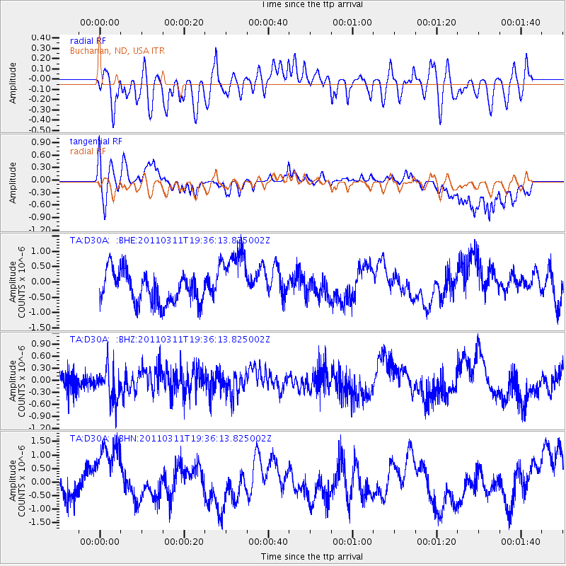
D30A Buchanan, ND, USA - Earthquake Result Viewer
*The percent match for this event was below the threshold and hence no stack was calculated.
| Earthquake location: |
Near East Coast Of Honshu, Japan |
| Earthquake latitude/longitude: |
35.7/140.7 |
| Earthquake time(UTC): |
2011/03/11 (070) 19:24:24 GMT |
| Earthquake Depth: |
2.2 km |
| Earthquake Magnitude: |
5.5 MB |
| Earthquake Catalog/Contributor: |
WHDF/NEIC |
|
| Network: |
TA USArray Transportable Network (new EarthScope stations) |
| Station: |
D30A Buchanan, ND, USA |
| Lat/Lon: |
47.11 N/98.76 W |
| Elevation: |
465 m |
|
| Distance: |
81.9 deg |
| Az: |
36.441 deg |
| Baz: |
314.934 deg |
| Ray Param: |
$rayparam |
*The percent match for this event was below the threshold and hence was not used in the summary stack. |
|
| Radial Match: |
44.383533 % |
| Radial Bump: |
400 |
| Transverse Match: |
69.00792 % |
| Transverse Bump: |
400 |
| SOD ConfigId: |
356183 |
| Insert Time: |
2011-08-18 05:49:02.710 +0000 |
| GWidth: |
2.5 |
| Max Bumps: |
400 |
| Tol: |
0.001 |
|
Signal To Noise
| Channel | StoN | STA | LTA |
| TA:D30A: :BHZ:20110311T19:36:13.825002Z | 1.1620202 | 4.0350685E-7 | 3.47246E-7 |
| TA:D30A: :BHN:20110311T19:36:13.825002Z | 2.136261 | 1.3293326E-6 | 6.222707E-7 |
| TA:D30A: :BHE:20110311T19:36:13.825002Z | 1.9978032 | 1.0089509E-6 | 5.0503013E-7 |
| Arrivals |
| Ps | |
| PpPs | |
| PsPs/PpSs | |


