You are here: Home > Network List > TA - USArray Transportable Network (new EarthScope stations) Stations List
> Station 633A Saathoff Ranch, Hondo, TX, USA > Earthquake Result Viewer
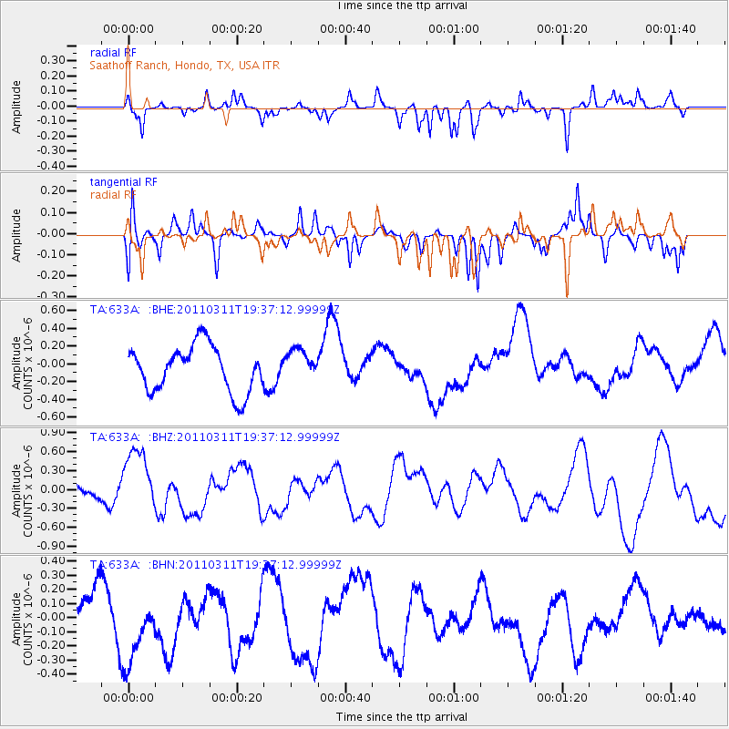
633A Saathoff Ranch, Hondo, TX, USA - Earthquake Result Viewer
*The percent match for this event was below the threshold and hence no stack was calculated.
| Earthquake location: |
Near East Coast Of Honshu, Japan |
| Earthquake latitude/longitude: |
35.7/140.7 |
| Earthquake time(UTC): |
2011/03/11 (070) 19:24:24 GMT |
| Earthquake Depth: |
2.2 km |
| Earthquake Magnitude: |
5.5 MB |
| Earthquake Catalog/Contributor: |
WHDF/NEIC |
|
| Network: |
TA USArray Transportable Network (new EarthScope stations) |
| Station: |
633A Saathoff Ranch, Hondo, TX, USA |
| Lat/Lon: |
29.46 N/99.18 W |
| Elevation: |
320 m |
|
| Distance: |
94.2 deg |
| Az: |
49.113 deg |
| Baz: |
315.114 deg |
| Ray Param: |
$rayparam |
*The percent match for this event was below the threshold and hence was not used in the summary stack. |
|
| Radial Match: |
49.901806 % |
| Radial Bump: |
236 |
| Transverse Match: |
42.055508 % |
| Transverse Bump: |
276 |
| SOD ConfigId: |
356183 |
| Insert Time: |
2011-08-18 06:01:49.759 +0000 |
| GWidth: |
2.5 |
| Max Bumps: |
400 |
| Tol: |
0.001 |
|
Signal To Noise
| Channel | StoN | STA | LTA |
| TA:633A: :BHZ:20110311T19:37:12.99999Z | 2.4472632 | 4.768603E-7 | 1.9485451E-7 |
| TA:633A: :BHN:20110311T19:37:12.99999Z | 2.1837482 | 4.1612458E-7 | 1.905552E-7 |
| TA:633A: :BHE:20110311T19:37:12.99999Z | 0.69035214 | 1.7705356E-7 | 2.564685E-7 |
| Arrivals |
| Ps | |
| PpPs | |
| PsPs/PpSs | |


