You are here: Home > Network List > TA - USArray Transportable Network (new EarthScope stations) Stations List
> Station 336A Riesel, TX, USA > Earthquake Result Viewer
336A Riesel, TX, USA - Earthquake Result Viewer
*The percent match for this event was below the threshold and hence no stack was calculated.
| Earthquake location: |
Near East Coast Of Honshu, Japan |
| Earthquake latitude/longitude: |
35.7/140.7 |
| Earthquake time(UTC): |
2011/03/11 (070) 19:24:24 GMT |
| Earthquake Depth: |
2.2 km |
| Earthquake Magnitude: |
5.5 MB |
| Earthquake Catalog/Contributor: |
WHDF/NEIC |
|
| Network: |
TA USArray Transportable Network (new EarthScope stations) |
| Station: |
336A Riesel, TX, USA |
| Lat/Lon: |
31.39 N/96.84 W |
| Elevation: |
140 m |
|
| Distance: |
94.2 deg |
| Az: |
46.322 deg |
| Baz: |
316.492 deg |
| Ray Param: |
$rayparam |
*The percent match for this event was below the threshold and hence was not used in the summary stack. |
|
| Radial Match: |
50.660503 % |
| Radial Bump: |
354 |
| Transverse Match: |
45.290043 % |
| Transverse Bump: |
374 |
| SOD ConfigId: |
356183 |
| Insert Time: |
2011-08-18 06:04:36.106 +0000 |
| GWidth: |
2.5 |
| Max Bumps: |
400 |
| Tol: |
0.001 |
|
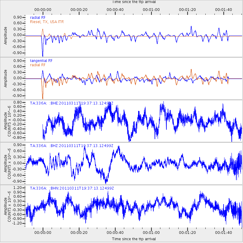
Signal To Noise
| Channel | StoN | STA | LTA |
| TA:336A: :BHZ:20110311T19:37:13.12499Z | 0.7720917 | 2.8538264E-7 | 3.696227E-7 |
| TA:336A: :BHN:20110311T19:37:13.12499Z | 0.5805621 | 2.886876E-7 | 4.972553E-7 |
| TA:336A: :BHE:20110311T19:37:13.12499Z | 0.65046024 | 2.2900477E-7 | 3.5206574E-7 |
| Arrivals |
| Ps | |
| PpPs | |
| PsPs/PpSs | |


