You are here: Home > Network List > TA - USArray Transportable Network (new EarthScope stations) Stations List
> Station I38A Scanlan Farm, Eyota, MN, USA > Earthquake Result Viewer
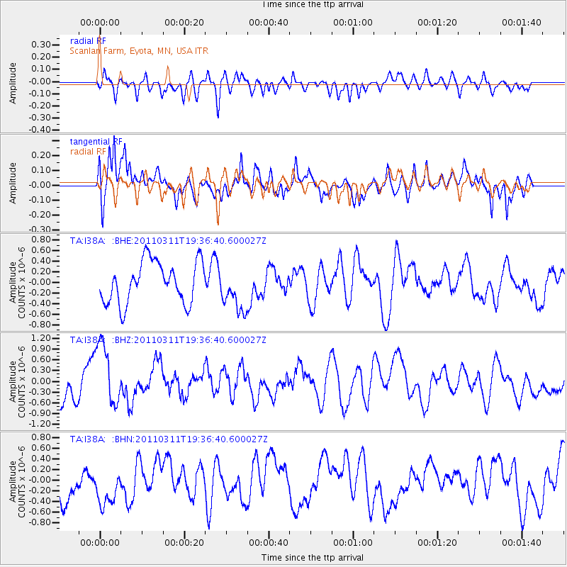
I38A Scanlan Farm, Eyota, MN, USA - Earthquake Result Viewer
*The percent match for this event was below the threshold and hence no stack was calculated.
| Earthquake location: |
Near East Coast Of Honshu, Japan |
| Earthquake latitude/longitude: |
35.7/140.7 |
| Earthquake time(UTC): |
2011/03/11 (070) 19:24:24 GMT |
| Earthquake Depth: |
2.2 km |
| Earthquake Magnitude: |
5.5 MB |
| Earthquake Catalog/Contributor: |
WHDF/NEIC |
|
| Network: |
TA USArray Transportable Network (new EarthScope stations) |
| Station: |
I38A Scanlan Farm, Eyota, MN, USA |
| Lat/Lon: |
44.04 N/92.33 W |
| Elevation: |
390 m |
|
| Distance: |
87.2 deg |
| Az: |
35.209 deg |
| Baz: |
319.395 deg |
| Ray Param: |
$rayparam |
*The percent match for this event was below the threshold and hence was not used in the summary stack. |
|
| Radial Match: |
44.757713 % |
| Radial Bump: |
400 |
| Transverse Match: |
57.300102 % |
| Transverse Bump: |
400 |
| SOD ConfigId: |
356183 |
| Insert Time: |
2011-08-18 06:20:43.159 +0000 |
| GWidth: |
2.5 |
| Max Bumps: |
400 |
| Tol: |
0.001 |
|
Signal To Noise
| Channel | StoN | STA | LTA |
| TA:I38A: :BHZ:20110311T19:36:40.600027Z | 3.172797 | 9.0864575E-7 | 2.8638635E-7 |
| TA:I38A: :BHN:20110311T19:36:40.600027Z | 1.5232136 | 4.4503338E-7 | 2.921674E-7 |
| TA:I38A: :BHE:20110311T19:36:40.600027Z | 1.1031724 | 4.3031096E-7 | 3.9006682E-7 |
| Arrivals |
| Ps | |
| PpPs | |
| PsPs/PpSs | |


