You are here: Home > Network List > TA - USArray Transportable Network (new EarthScope stations) Stations List
> Station E37A Wrenshall, MN, USA > Earthquake Result Viewer
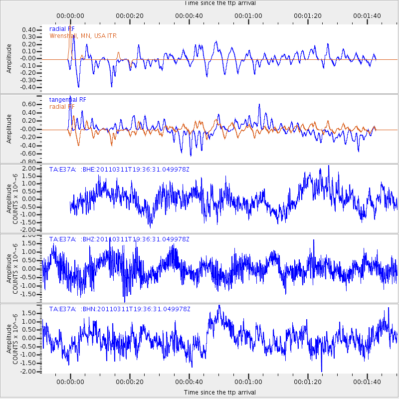
E37A Wrenshall, MN, USA - Earthquake Result Viewer
*The percent match for this event was below the threshold and hence no stack was calculated.
| Earthquake location: |
Near East Coast Of Honshu, Japan |
| Earthquake latitude/longitude: |
35.7/140.7 |
| Earthquake time(UTC): |
2011/03/11 (070) 19:24:24 GMT |
| Earthquake Depth: |
2.2 km |
| Earthquake Magnitude: |
5.5 MB |
| Earthquake Catalog/Contributor: |
WHDF/NEIC |
|
| Network: |
TA USArray Transportable Network (new EarthScope stations) |
| Station: |
E37A Wrenshall, MN, USA |
| Lat/Lon: |
46.57 N/92.40 W |
| Elevation: |
304 m |
|
| Distance: |
85.3 deg |
| Az: |
33.597 deg |
| Baz: |
319.24 deg |
| Ray Param: |
$rayparam |
*The percent match for this event was below the threshold and hence was not used in the summary stack. |
|
| Radial Match: |
55.97785 % |
| Radial Bump: |
400 |
| Transverse Match: |
60.657196 % |
| Transverse Bump: |
326 |
| SOD ConfigId: |
356183 |
| Insert Time: |
2011-08-18 06:21:14.008 +0000 |
| GWidth: |
2.5 |
| Max Bumps: |
400 |
| Tol: |
0.001 |
|
Signal To Noise
| Channel | StoN | STA | LTA |
| TA:E37A: :BHZ:20110311T19:36:31.049978Z | 1.2991126 | 7.38899E-7 | 5.687721E-7 |
| TA:E37A: :BHN:20110311T19:36:31.049978Z | 1.4261041 | 7.409708E-7 | 5.19577E-7 |
| TA:E37A: :BHE:20110311T19:36:31.049978Z | 0.95469564 | 5.1206877E-7 | 5.3636865E-7 |
| Arrivals |
| Ps | |
| PpPs | |
| PsPs/PpSs | |


