You are here: Home > Network List > TA - USArray Transportable Network (new EarthScope stations) Stations List
> Station H17A Grant Village (NPS), Yellowstone Nt. Park, WY, USA > Earthquake Result Viewer
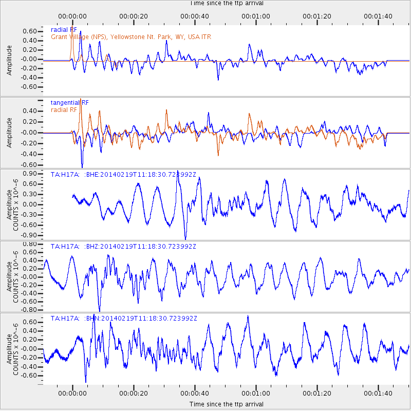
H17A Grant Village (NPS), Yellowstone Nt. Park, WY, USA - Earthquake Result Viewer
*The percent match for this event was below the threshold and hence no stack was calculated.
| Earthquake location: |
Venezuela |
| Earthquake latitude/longitude: |
9.7/-69.8 |
| Earthquake time(UTC): |
2014/02/19 (050) 11:10:13 GMT |
| Earthquake Depth: |
20 km |
| Earthquake Magnitude: |
5.3 MW |
| Earthquake Catalog/Contributor: |
ISC/ISC |
|
| Network: |
TA USArray Transportable Network (new EarthScope stations) |
| Station: |
H17A Grant Village (NPS), Yellowstone Nt. Park, WY, USA |
| Lat/Lon: |
44.40 N/110.58 W |
| Elevation: |
2400 m |
|
| Distance: |
49.4 deg |
| Az: |
321.861 deg |
| Baz: |
121.856 deg |
| Ray Param: |
$rayparam |
*The percent match for this event was below the threshold and hence was not used in the summary stack. |
|
| Radial Match: |
50.537224 % |
| Radial Bump: |
400 |
| Transverse Match: |
62.84458 % |
| Transverse Bump: |
400 |
| SOD ConfigId: |
3390531 |
| Insert Time: |
2019-04-10 09:33:27.251 +0000 |
| GWidth: |
2.5 |
| Max Bumps: |
400 |
| Tol: |
0.001 |
|
Signal To Noise
| Channel | StoN | STA | LTA |
| TA:H17A: :BHZ:20140219T11:18:30.723992Z | 1.7780547 | 3.3713854E-7 | 1.896109E-7 |
| TA:H17A: :BHN:20140219T11:18:30.723992Z | 1.1361129 | 2.5532185E-7 | 2.2473283E-7 |
| TA:H17A: :BHE:20140219T11:18:30.723992Z | 1.7722024 | 4.8856106E-7 | 2.7568018E-7 |
| Arrivals |
| Ps | |
| PpPs | |
| PsPs/PpSs | |


