You are here: Home > Network List > MN - MEDNET Project Stations List
> Station TIP Timpagrande, Italy > Earthquake Result Viewer
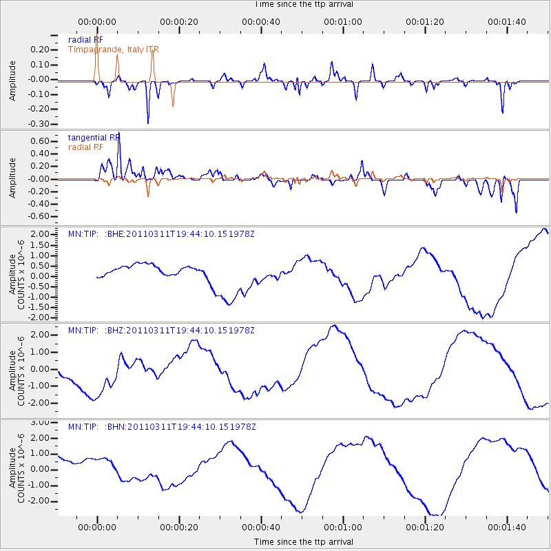
TIP Timpagrande, Italy - Earthquake Result Viewer
*The percent match for this event was below the threshold and hence no stack was calculated.
| Earthquake location: |
Eastern Honshu, Japan |
| Earthquake latitude/longitude: |
36.9/138.3 |
| Earthquake time(UTC): |
2011/03/11 (070) 19:31:56 GMT |
| Earthquake Depth: |
12 km |
| Earthquake Magnitude: |
5.5 MB, 5.7 MS |
| Earthquake Catalog/Contributor: |
WHDF/NEIC |
|
| Network: |
MN MEDNET Project |
| Station: |
TIP Timpagrande, Italy |
| Lat/Lon: |
39.18 N/16.76 E |
| Elevation: |
789 m |
|
| Distance: |
87.1 deg |
| Az: |
318.45 deg |
| Baz: |
43.132 deg |
| Ray Param: |
$rayparam |
*The percent match for this event was below the threshold and hence was not used in the summary stack. |
|
| Radial Match: |
76.49905 % |
| Radial Bump: |
321 |
| Transverse Match: |
82.69755 % |
| Transverse Bump: |
400 |
| SOD ConfigId: |
356183 |
| Insert Time: |
2011-08-18 07:23:08.121 +0000 |
| GWidth: |
2.5 |
| Max Bumps: |
400 |
| Tol: |
0.001 |
|
Signal To Noise
| Channel | StoN | STA | LTA |
| MN:TIP: :BHZ:20110311T19:44:10.151978Z | 2.1571927 | 1.4067897E-6 | 6.5213914E-7 |
| MN:TIP: :BHN:20110311T19:44:10.151978Z | 1.3040342 | 6.872292E-7 | 5.2700244E-7 |
| MN:TIP: :BHE:20110311T19:44:10.151978Z | 6.5325766 | 1.418025E-6 | 2.1706978E-7 |
| Arrivals |
| Ps | |
| PpPs | |
| PsPs/PpSs | |


