You are here: Home > Network List > TA - USArray Transportable Network (new EarthScope stations) Stations List
> Station S33A Kaszmaul Farm, Murdock, KS, USA > Earthquake Result Viewer
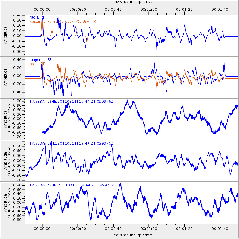
S33A Kaszmaul Farm, Murdock, KS, USA - Earthquake Result Viewer
*The percent match for this event was below the threshold and hence no stack was calculated.
| Earthquake location: |
Eastern Honshu, Japan |
| Earthquake latitude/longitude: |
36.9/138.3 |
| Earthquake time(UTC): |
2011/03/11 (070) 19:31:56 GMT |
| Earthquake Depth: |
12 km |
| Earthquake Magnitude: |
5.5 MB, 5.7 MS |
| Earthquake Catalog/Contributor: |
WHDF/NEIC |
|
| Network: |
TA USArray Transportable Network (new EarthScope stations) |
| Station: |
S33A Kaszmaul Farm, Murdock, KS, USA |
| Lat/Lon: |
37.59 N/98.00 W |
| Elevation: |
471 m |
|
| Distance: |
89.4 deg |
| Az: |
41.368 deg |
| Baz: |
318.196 deg |
| Ray Param: |
$rayparam |
*The percent match for this event was below the threshold and hence was not used in the summary stack. |
|
| Radial Match: |
57.77693 % |
| Radial Bump: |
400 |
| Transverse Match: |
67.12182 % |
| Transverse Bump: |
328 |
| SOD ConfigId: |
356183 |
| Insert Time: |
2011-08-18 07:40:05.633 +0000 |
| GWidth: |
2.5 |
| Max Bumps: |
400 |
| Tol: |
0.001 |
|
Signal To Noise
| Channel | StoN | STA | LTA |
| TA:S33A: :BHZ:20110311T19:44:21.099976Z | 2.2695432 | 7.221913E-7 | 3.1821E-7 |
| TA:S33A: :BHN:20110311T19:44:21.099976Z | 0.7676548 | 3.3909689E-7 | 4.4173095E-7 |
| TA:S33A: :BHE:20110311T19:44:21.099976Z | 1.200003 | 6.914363E-7 | 5.761955E-7 |
| Arrivals |
| Ps | |
| PpPs | |
| PsPs/PpSs | |


