You are here: Home > Network List > TA - USArray Transportable Network (new EarthScope stations) Stations List
> Station X33A Lawton, OK, USA > Earthquake Result Viewer
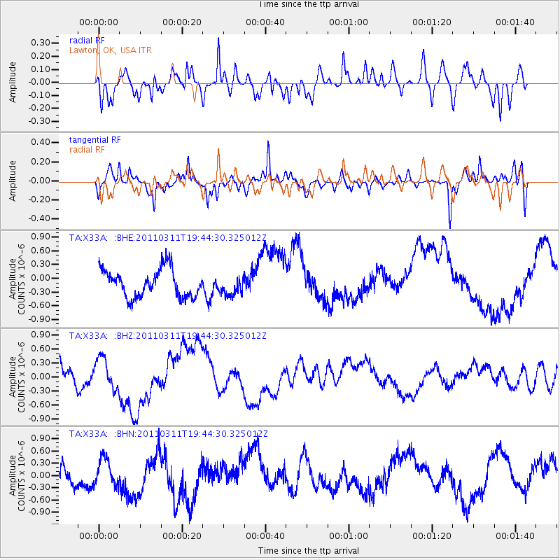
X33A Lawton, OK, USA - Earthquake Result Viewer
*The percent match for this event was below the threshold and hence no stack was calculated.
| Earthquake location: |
Eastern Honshu, Japan |
| Earthquake latitude/longitude: |
36.9/138.3 |
| Earthquake time(UTC): |
2011/03/11 (070) 19:31:56 GMT |
| Earthquake Depth: |
12 km |
| Earthquake Magnitude: |
5.5 MB, 5.7 MS |
| Earthquake Catalog/Contributor: |
WHDF/NEIC |
|
| Network: |
TA USArray Transportable Network (new EarthScope stations) |
| Station: |
X33A Lawton, OK, USA |
| Lat/Lon: |
34.54 N/98.50 W |
| Elevation: |
346 m |
|
| Distance: |
91.4 deg |
| Az: |
43.706 deg |
| Baz: |
317.887 deg |
| Ray Param: |
$rayparam |
*The percent match for this event was below the threshold and hence was not used in the summary stack. |
|
| Radial Match: |
71.77465 % |
| Radial Bump: |
400 |
| Transverse Match: |
62.34217 % |
| Transverse Bump: |
375 |
| SOD ConfigId: |
356183 |
| Insert Time: |
2011-08-18 07:42:06.192 +0000 |
| GWidth: |
2.5 |
| Max Bumps: |
400 |
| Tol: |
0.001 |
|
Signal To Noise
| Channel | StoN | STA | LTA |
| TA:X33A: :BHZ:20110311T19:44:30.325012Z | 1.1534795 | 3.7166635E-7 | 3.2221322E-7 |
| TA:X33A: :BHN:20110311T19:44:30.325012Z | 0.7785198 | 3.3380235E-7 | 4.287654E-7 |
| TA:X33A: :BHE:20110311T19:44:30.325012Z | 0.6752871 | 2.0440348E-7 | 3.026912E-7 |
| Arrivals |
| Ps | |
| PpPs | |
| PsPs/PpSs | |


