You are here: Home > Network List > TA - USArray Transportable Network (new EarthScope stations) Stations List
> Station T36A Boggs Farm, Caney, KS, USA > Earthquake Result Viewer
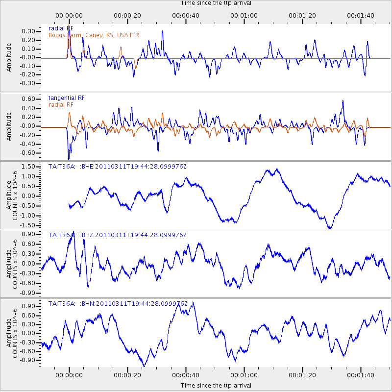
T36A Boggs Farm, Caney, KS, USA - Earthquake Result Viewer
*The percent match for this event was below the threshold and hence no stack was calculated.
| Earthquake location: |
Eastern Honshu, Japan |
| Earthquake latitude/longitude: |
36.9/138.3 |
| Earthquake time(UTC): |
2011/03/11 (070) 19:31:56 GMT |
| Earthquake Depth: |
12 km |
| Earthquake Magnitude: |
5.5 MB, 5.7 MS |
| Earthquake Catalog/Contributor: |
WHDF/NEIC |
|
| Network: |
TA USArray Transportable Network (new EarthScope stations) |
| Station: |
T36A Boggs Farm, Caney, KS, USA |
| Lat/Lon: |
37.06 N/95.88 W |
| Elevation: |
243 m |
|
| Distance: |
90.9 deg |
| Az: |
40.445 deg |
| Baz: |
319.48 deg |
| Ray Param: |
$rayparam |
*The percent match for this event was below the threshold and hence was not used in the summary stack. |
|
| Radial Match: |
73.50421 % |
| Radial Bump: |
350 |
| Transverse Match: |
52.694534 % |
| Transverse Bump: |
260 |
| SOD ConfigId: |
356183 |
| Insert Time: |
2011-08-18 07:51:36.408 +0000 |
| GWidth: |
2.5 |
| Max Bumps: |
400 |
| Tol: |
0.001 |
|
Signal To Noise
| Channel | StoN | STA | LTA |
| TA:T36A: :BHZ:20110311T19:44:28.099976Z | 2.3221047 | 6.421314E-7 | 2.765299E-7 |
| TA:T36A: :BHN:20110311T19:44:28.099976Z | 0.7206581 | 2.1250945E-7 | 2.9488245E-7 |
| TA:T36A: :BHE:20110311T19:44:28.099976Z | 1.1162974 | 3.819839E-7 | 3.4218832E-7 |
| Arrivals |
| Ps | |
| PpPs | |
| PsPs/PpSs | |


