You are here: Home > Network List > TA - USArray Transportable Network (new EarthScope stations) Stations List
> Station I31A Royce, Wessington Springs, SD, USA > Earthquake Result Viewer
I31A Royce, Wessington Springs, SD, USA - Earthquake Result Viewer
| Earthquake location: |
Eastern Honshu, Japan |
| Earthquake latitude/longitude: |
36.9/138.3 |
| Earthquake time(UTC): |
2011/03/11 (070) 19:31:56 GMT |
| Earthquake Depth: |
12 km |
| Earthquake Magnitude: |
5.5 MB, 5.7 MS |
| Earthquake Catalog/Contributor: |
WHDF/NEIC |
|
| Network: |
TA USArray Transportable Network (new EarthScope stations) |
| Station: |
I31A Royce, Wessington Springs, SD, USA |
| Lat/Lon: |
44.03 N/98.54 W |
| Elevation: |
469 m |
|
| Distance: |
84.4 deg |
| Az: |
37.355 deg |
| Baz: |
317.629 deg |
| Ray Param: |
0.045538213 |
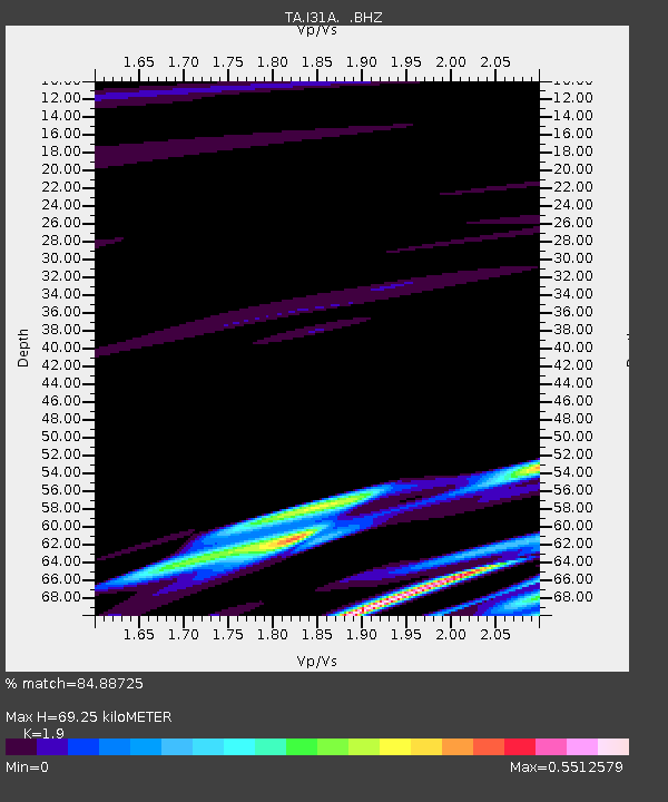
| Estimated Moho Depth: |
69.25 km |
| Estimated Crust Vp/Vs: |
1.90 |
| Assumed Crust Vp: |
6.53 km/s |
| Estimated Crust Vs: |
3.437 km/s |
| Estimated Crust Poisson's Ratio: |
0.31 |
|
| Radial Match: |
84.88725 % |
| Radial Bump: |
371 |
| Transverse Match: |
89.06204 % |
| Transverse Bump: |
309 |
| SOD ConfigId: |
356183 |
| Insert Time: |
2011-08-18 07:58:50.034 +0000 |
| GWidth: |
2.5 |
| Max Bumps: |
400 |
| Tol: |
0.001 |
|

Signal To Noise
| Channel | StoN | STA | LTA |
| TA:I31A: :BHZ:20110311T19:43:56.599976Z | 1.8148863 | 1.4008E-6 | 7.718389E-7 |
| TA:I31A: :BHN:20110311T19:43:56.599976Z | 1.5364188 | 1.635726E-6 | 1.0646355E-6 |
| TA:I31A: :BHE:20110311T19:43:56.599976Z | 1.2931354 | 1.8510137E-6 | 1.4314153E-6 |
| Arrivals |
| Ps | 9.8 SECOND |
| PpPs | 30 SECOND |
| PsPs/PpSs | 40 SECOND |


