You are here: Home > Network List > TA - USArray Transportable Network (new EarthScope stations) Stations List
> Station F33A 5 Mile Ranch, Herman, MN, USA > Earthquake Result Viewer
F33A 5 Mile Ranch, Herman, MN, USA - Earthquake Result Viewer
| Earthquake location: |
Eastern Honshu, Japan |
| Earthquake latitude/longitude: |
36.9/138.3 |
| Earthquake time(UTC): |
2011/03/11 (070) 19:31:56 GMT |
| Earthquake Depth: |
12 km |
| Earthquake Magnitude: |
5.5 MB, 5.7 MS |
| Earthquake Catalog/Contributor: |
WHDF/NEIC |
|
| Network: |
TA USArray Transportable Network (new EarthScope stations) |
| Station: |
F33A 5 Mile Ranch, Herman, MN, USA |
| Lat/Lon: |
45.84 N/96.29 W |
| Elevation: |
313 m |
|
| Distance: |
84.1 deg |
| Az: |
34.949 deg |
| Baz: |
318.965 deg |
| Ray Param: |
0.045739926 |
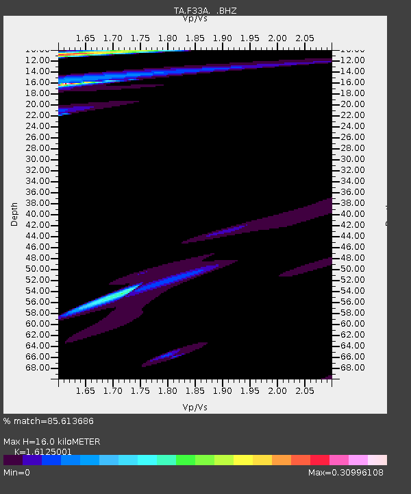
| Estimated Moho Depth: |
16.0 km |
| Estimated Crust Vp/Vs: |
1.61 |
| Assumed Crust Vp: |
6.552 km/s |
| Estimated Crust Vs: |
4.064 km/s |
| Estimated Crust Poisson's Ratio: |
0.19 |
|
| Radial Match: |
85.613686 % |
| Radial Bump: |
301 |
| Transverse Match: |
68.733246 % |
| Transverse Bump: |
170 |
| SOD ConfigId: |
356183 |
| Insert Time: |
2011-08-18 08:02:29.079 +0000 |
| GWidth: |
2.5 |
| Max Bumps: |
400 |
| Tol: |
0.001 |
|
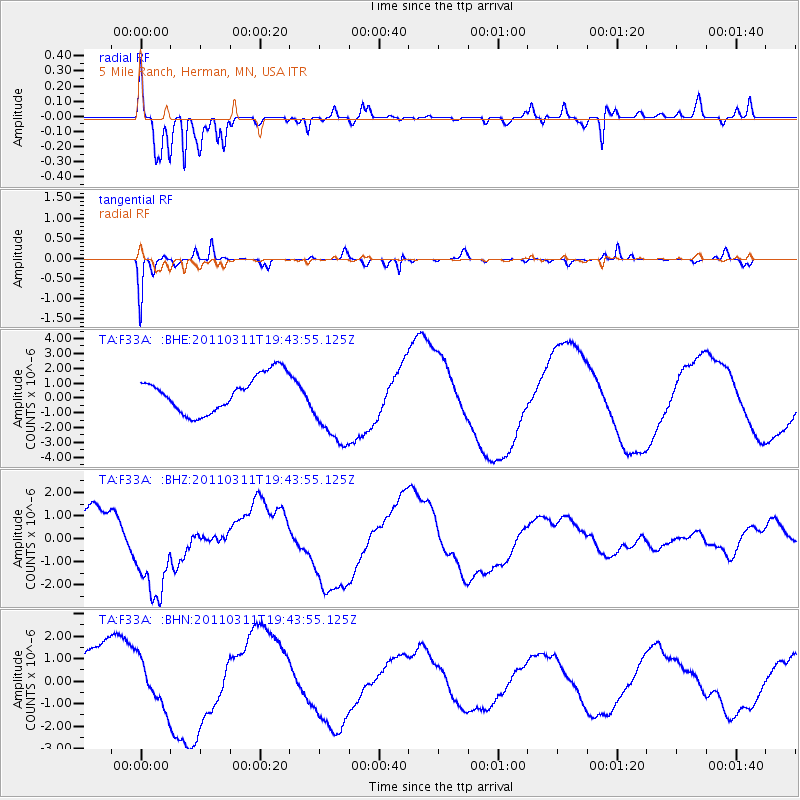
Signal To Noise
| Channel | StoN | STA | LTA |
| TA:F33A: :BHZ:20110311T19:43:55.125Z | 2.0928679 | 2.0034136E-6 | 9.572576E-7 |
| TA:F33A: :BHN:20110311T19:43:55.125Z | 0.7545889 | 1.0623291E-6 | 1.407825E-6 |
| TA:F33A: :BHE:20110311T19:43:55.125Z | 2.2714393 | 2.7731703E-6 | 1.2208868E-6 |
| Arrivals |
| Ps | 1.5 SECOND |
| PpPs | 6.2 SECOND |
| PsPs/PpSs | 7.7 SECOND |


