You are here: Home > Network List > US - United States National Seismic Network Stations List
> Station WMOK Wichita Mountains, Oklahoma, USA > Earthquake Result Viewer
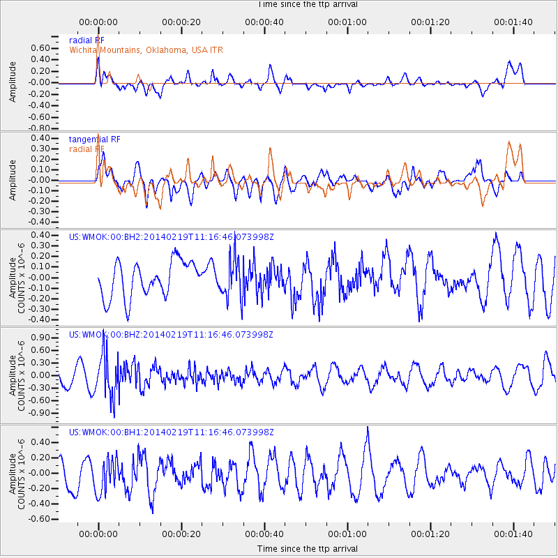
WMOK Wichita Mountains, Oklahoma, USA - Earthquake Result Viewer
*The percent match for this event was below the threshold and hence no stack was calculated.
| Earthquake location: |
Venezuela |
| Earthquake latitude/longitude: |
9.7/-69.8 |
| Earthquake time(UTC): |
2014/02/19 (050) 11:10:13 GMT |
| Earthquake Depth: |
20 km |
| Earthquake Magnitude: |
5.3 MW |
| Earthquake Catalog/Contributor: |
ISC/ISC |
|
| Network: |
US United States National Seismic Network |
| Station: |
WMOK Wichita Mountains, Oklahoma, USA |
| Lat/Lon: |
34.74 N/98.78 W |
| Elevation: |
486 m |
|
| Distance: |
36.4 deg |
| Az: |
317.693 deg |
| Baz: |
126.308 deg |
| Ray Param: |
$rayparam |
*The percent match for this event was below the threshold and hence was not used in the summary stack. |
|
| Radial Match: |
70.884445 % |
| Radial Bump: |
400 |
| Transverse Match: |
76.53251 % |
| Transverse Bump: |
400 |
| SOD ConfigId: |
3390531 |
| Insert Time: |
2019-04-10 09:34:40.416 +0000 |
| GWidth: |
2.5 |
| Max Bumps: |
400 |
| Tol: |
0.001 |
|
Signal To Noise
| Channel | StoN | STA | LTA |
| US:WMOK:00:BHZ:20140219T11:16:46.073998Z | 2.1079695 | 5.124191E-7 | 2.430866E-7 |
| US:WMOK:00:BH1:20140219T11:16:46.073998Z | 1.2356213 | 2.2098048E-7 | 1.788416E-7 |
| US:WMOK:00:BH2:20140219T11:16:46.073998Z | 1.1407726 | 1.8985124E-7 | 1.6642339E-7 |
| Arrivals |
| Ps | |
| PpPs | |
| PsPs/PpSs | |


