You are here: Home > Network List > TA - USArray Transportable Network (new EarthScope stations) Stations List
> Station SFIN Lafayette, IN, USA > Earthquake Result Viewer
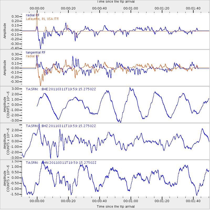
SFIN Lafayette, IN, USA - Earthquake Result Viewer
*The percent match for this event was below the threshold and hence no stack was calculated.
| Earthquake location: |
Near West Coast Of Honshu, Japan |
| Earthquake latitude/longitude: |
40.5/139.1 |
| Earthquake time(UTC): |
2011/03/11 (070) 19:46:50 GMT |
| Earthquake Depth: |
10 km |
| Earthquake Magnitude: |
6.2 MB, 6.1 MS, 6.2 MW |
| Earthquake Catalog/Contributor: |
WHDF/NEIC |
|
| Network: |
TA USArray Transportable Network (new EarthScope stations) |
| Station: |
SFIN Lafayette, IN, USA |
| Lat/Lon: |
40.38 N/87.10 W |
| Elevation: |
165 m |
|
| Distance: |
89.2 deg |
| Az: |
33.434 deg |
| Baz: |
326.624 deg |
| Ray Param: |
$rayparam |
*The percent match for this event was below the threshold and hence was not used in the summary stack. |
|
| Radial Match: |
72.90298 % |
| Radial Bump: |
400 |
| Transverse Match: |
65.46004 % |
| Transverse Bump: |
289 |
| SOD ConfigId: |
356183 |
| Insert Time: |
2011-08-18 09:06:06.990 +0000 |
| GWidth: |
2.5 |
| Max Bumps: |
400 |
| Tol: |
0.001 |
|
Signal To Noise
| Channel | StoN | STA | LTA |
| TA:SFIN: :BHZ:20110311T19:59:15.27502Z | 1.3216604 | 1.8412775E-6 | 1.3931547E-6 |
| TA:SFIN: :BHN:20110311T19:59:15.27502Z | 0.7849297 | 9.023177E-7 | 1.1495523E-6 |
| TA:SFIN: :BHE:20110311T19:59:15.27502Z | 0.6659982 | 9.382053E-7 | 1.4087203E-6 |
| Arrivals |
| Ps | |
| PpPs | |
| PsPs/PpSs | |


