You are here: Home > Network List > TA - USArray Transportable Network (new EarthScope stations) Stations List
> Station KSCO Kaye Shedlock's, Cheyenne Wells, CO, USA > Earthquake Result Viewer
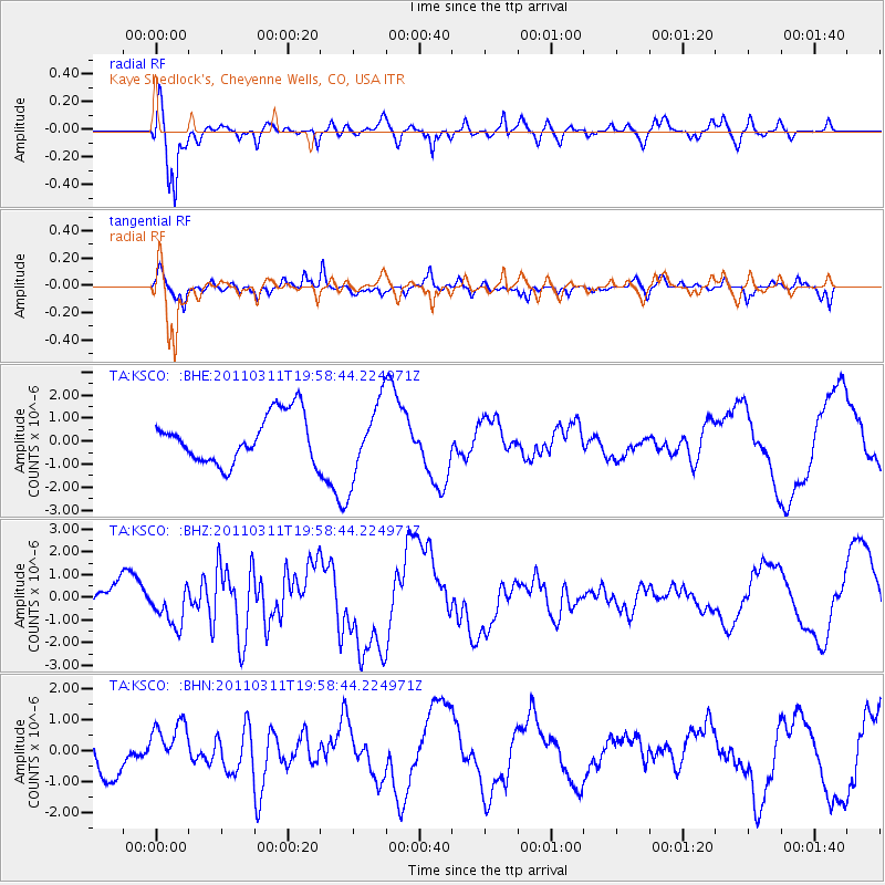
KSCO Kaye Shedlock's, Cheyenne Wells, CO, USA - Earthquake Result Viewer
*The percent match for this event was below the threshold and hence no stack was calculated.
| Earthquake location: |
Near West Coast Of Honshu, Japan |
| Earthquake latitude/longitude: |
40.5/139.1 |
| Earthquake time(UTC): |
2011/03/11 (070) 19:46:50 GMT |
| Earthquake Depth: |
10 km |
| Earthquake Magnitude: |
6.2 MB, 6.1 MS, 6.2 MW |
| Earthquake Catalog/Contributor: |
WHDF/NEIC |
|
| Network: |
TA USArray Transportable Network (new EarthScope stations) |
| Station: |
KSCO Kaye Shedlock's, Cheyenne Wells, CO, USA |
| Lat/Lon: |
39.01 N/102.63 W |
| Elevation: |
1382 m |
|
| Distance: |
82.9 deg |
| Az: |
43.721 deg |
| Baz: |
317.417 deg |
| Ray Param: |
$rayparam |
*The percent match for this event was below the threshold and hence was not used in the summary stack. |
|
| Radial Match: |
75.81169 % |
| Radial Bump: |
384 |
| Transverse Match: |
45.43637 % |
| Transverse Bump: |
260 |
| SOD ConfigId: |
356183 |
| Insert Time: |
2011-08-18 09:06:56.161 +0000 |
| GWidth: |
2.5 |
| Max Bumps: |
400 |
| Tol: |
0.001 |
|
Signal To Noise
| Channel | StoN | STA | LTA |
| TA:KSCO: :BHZ:20110311T19:58:44.224971Z | 1.6528636 | 8.722983E-7 | 5.277497E-7 |
| TA:KSCO: :BHN:20110311T19:58:44.224971Z | 1.7764487 | 8.4145955E-7 | 4.7367513E-7 |
| TA:KSCO: :BHE:20110311T19:58:44.224971Z | 1.5627661 | 1.6089474E-6 | 1.0295511E-6 |
| Arrivals |
| Ps | |
| PpPs | |
| PsPs/PpSs | |


