You are here: Home > Network List > TA - USArray Transportable Network (new EarthScope stations) Stations List
> Station L32A Elgin, NE, USA > Earthquake Result Viewer
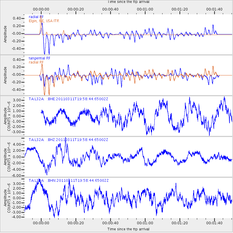
L32A Elgin, NE, USA - Earthquake Result Viewer
*The percent match for this event was below the threshold and hence no stack was calculated.
| Earthquake location: |
Near West Coast Of Honshu, Japan |
| Earthquake latitude/longitude: |
40.5/139.1 |
| Earthquake time(UTC): |
2011/03/11 (070) 19:46:50 GMT |
| Earthquake Depth: |
10 km |
| Earthquake Magnitude: |
6.2 MB, 6.1 MS, 6.2 MW |
| Earthquake Catalog/Contributor: |
WHDF/NEIC |
|
| Network: |
TA USArray Transportable Network (new EarthScope stations) |
| Station: |
L32A Elgin, NE, USA |
| Lat/Lon: |
42.00 N/98.01 W |
| Elevation: |
586 m |
|
| Distance: |
83.0 deg |
| Az: |
39.068 deg |
| Baz: |
319.836 deg |
| Ray Param: |
$rayparam |
*The percent match for this event was below the threshold and hence was not used in the summary stack. |
|
| Radial Match: |
88.30202 % |
| Radial Bump: |
400 |
| Transverse Match: |
87.351135 % |
| Transverse Bump: |
400 |
| SOD ConfigId: |
356183 |
| Insert Time: |
2011-08-18 09:25:30.491 +0000 |
| GWidth: |
2.5 |
| Max Bumps: |
400 |
| Tol: |
0.001 |
|
Signal To Noise
| Channel | StoN | STA | LTA |
| TA:L32A: :BHZ:20110311T19:58:44.65002Z | 1.621928 | 3.018937E-6 | 1.8613262E-6 |
| TA:L32A: :BHN:20110311T19:58:44.65002Z | 1.4896952 | 2.4130452E-6 | 1.6198248E-6 |
| TA:L32A: :BHE:20110311T19:58:44.65002Z | 0.68078226 | 6.161451E-7 | 9.050546E-7 |
| Arrivals |
| Ps | |
| PpPs | |
| PsPs/PpSs | |


