You are here: Home > Network List > TA - USArray Transportable Network (new EarthScope stations) Stations List
> Station I35A Creekview Farms, Bingham Lake, MN, USA > Earthquake Result Viewer
I35A Creekview Farms, Bingham Lake, MN, USA - Earthquake Result Viewer
| Earthquake location: |
Near West Coast Of Honshu, Japan |
| Earthquake latitude/longitude: |
40.5/139.1 |
| Earthquake time(UTC): |
2011/03/11 (070) 19:46:50 GMT |
| Earthquake Depth: |
10 km |
| Earthquake Magnitude: |
6.2 MB, 6.1 MS, 6.2 MW |
| Earthquake Catalog/Contributor: |
WHDF/NEIC |
|
| Network: |
TA USArray Transportable Network (new EarthScope stations) |
| Station: |
I35A Creekview Farms, Bingham Lake, MN, USA |
| Lat/Lon: |
43.86 N/94.98 W |
| Elevation: |
428 m |
|
| Distance: |
83.0 deg |
| Az: |
36.154 deg |
| Baz: |
321.534 deg |
| Ray Param: |
0.04652102 |
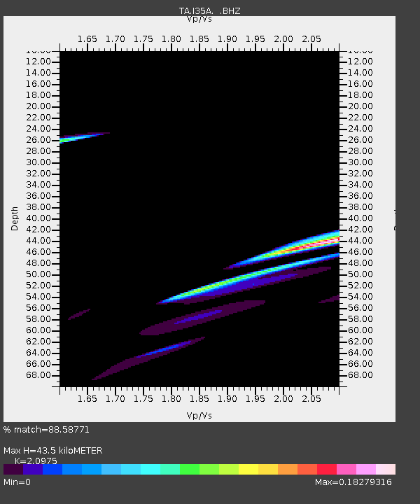
| Estimated Moho Depth: |
43.5 km |
| Estimated Crust Vp/Vs: |
2.10 |
| Assumed Crust Vp: |
6.53 km/s |
| Estimated Crust Vs: |
3.113 km/s |
| Estimated Crust Poisson's Ratio: |
0.35 |
|
| Radial Match: |
88.58771 % |
| Radial Bump: |
400 |
| Transverse Match: |
41.79925 % |
| Transverse Bump: |
400 |
| SOD ConfigId: |
356183 |
| Insert Time: |
2011-08-18 09:26:10.665 +0000 |
| GWidth: |
2.5 |
| Max Bumps: |
400 |
| Tol: |
0.001 |
|
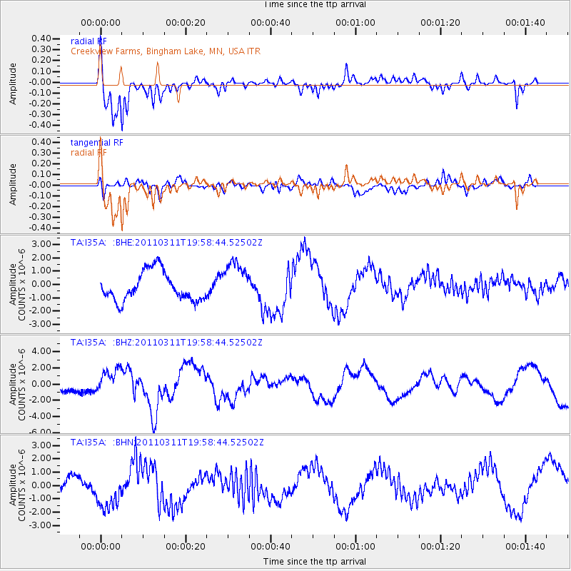
Signal To Noise
| Channel | StoN | STA | LTA |
| TA:I35A: :BHZ:20110311T19:58:44.52502Z | 1.8266648 | 1.6194335E-6 | 8.8655213E-7 |
| TA:I35A: :BHN:20110311T19:58:44.52502Z | 2.158342 | 1.4559645E-6 | 6.7457546E-7 |
| TA:I35A: :BHE:20110311T19:58:44.52502Z | 1.4573661 | 1.5687318E-6 | 1.0764157E-6 |
| Arrivals |
| Ps | 7.5 SECOND |
| PpPs | 20 SECOND |
| PsPs/PpSs | 28 SECOND |


