You are here: Home > Network List > TA - USArray Transportable Network (new EarthScope stations) Stations List
> Station S38A Stockton, MO, USA > Earthquake Result Viewer
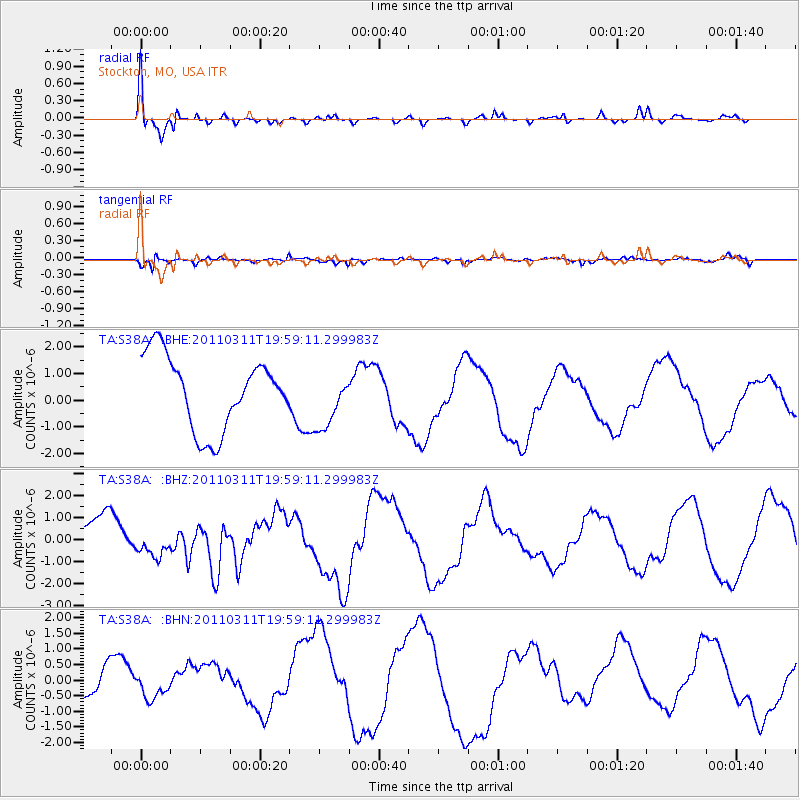
S38A Stockton, MO, USA - Earthquake Result Viewer
*The percent match for this event was below the threshold and hence no stack was calculated.
| Earthquake location: |
Near West Coast Of Honshu, Japan |
| Earthquake latitude/longitude: |
40.5/139.1 |
| Earthquake time(UTC): |
2011/03/11 (070) 19:46:50 GMT |
| Earthquake Depth: |
10 km |
| Earthquake Magnitude: |
6.2 MB, 6.1 MS, 6.2 MW |
| Earthquake Catalog/Contributor: |
WHDF/NEIC |
|
| Network: |
TA USArray Transportable Network (new EarthScope stations) |
| Station: |
S38A Stockton, MO, USA |
| Lat/Lon: |
37.63 N/93.91 W |
| Elevation: |
294 m |
|
| Distance: |
88.4 deg |
| Az: |
39.347 deg |
| Baz: |
322.475 deg |
| Ray Param: |
$rayparam |
*The percent match for this event was below the threshold and hence was not used in the summary stack. |
|
| Radial Match: |
72.74929 % |
| Radial Bump: |
400 |
| Transverse Match: |
55.92914 % |
| Transverse Bump: |
336 |
| SOD ConfigId: |
356183 |
| Insert Time: |
2011-08-18 09:33:36.629 +0000 |
| GWidth: |
2.5 |
| Max Bumps: |
400 |
| Tol: |
0.001 |
|
Signal To Noise
| Channel | StoN | STA | LTA |
| TA:S38A: :BHZ:20110311T19:59:11.299983Z | 0.5673105 | 8.920942E-7 | 1.5724972E-6 |
| TA:S38A: :BHN:20110311T19:59:11.299983Z | 0.17326058 | 2.556235E-7 | 1.47537E-6 |
| TA:S38A: :BHE:20110311T19:59:11.299983Z | 0.78665924 | 1.0697718E-6 | 1.3598923E-6 |
| Arrivals |
| Ps | |
| PpPs | |
| PsPs/PpSs | |


