You are here: Home > Network List > US - United States National Seismic Network Stations List
> Station AMTX Amarillo, Texas, USA > Earthquake Result Viewer
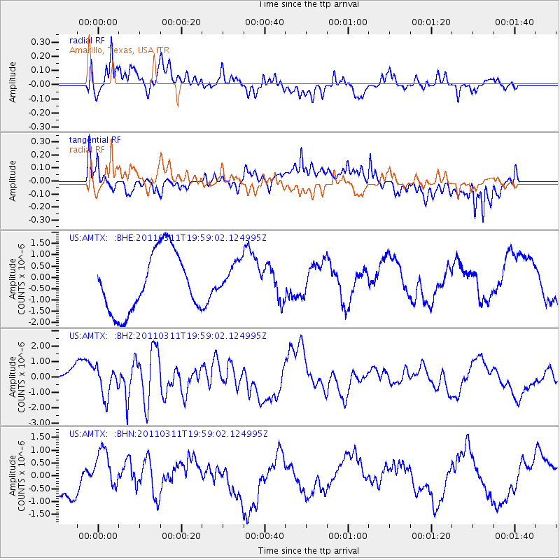
AMTX Amarillo, Texas, USA - Earthquake Result Viewer
*The percent match for this event was below the threshold and hence no stack was calculated.
| Earthquake location: |
Near West Coast Of Honshu, Japan |
| Earthquake latitude/longitude: |
40.5/139.1 |
| Earthquake time(UTC): |
2011/03/11 (070) 19:46:50 GMT |
| Earthquake Depth: |
10 km |
| Earthquake Magnitude: |
6.2 MB, 6.1 MS, 6.2 MW |
| Earthquake Catalog/Contributor: |
WHDF/NEIC |
|
| Network: |
US United States National Seismic Network |
| Station: |
AMTX Amarillo, Texas, USA |
| Lat/Lon: |
34.53 N/101.41 W |
| Elevation: |
1010 m |
|
| Distance: |
86.9 deg |
| Az: |
46.003 deg |
| Baz: |
318.348 deg |
| Ray Param: |
$rayparam |
*The percent match for this event was below the threshold and hence was not used in the summary stack. |
|
| Radial Match: |
53.287674 % |
| Radial Bump: |
400 |
| Transverse Match: |
58.87716 % |
| Transverse Bump: |
400 |
| SOD ConfigId: |
356183 |
| Insert Time: |
2011-08-18 09:42:05.924 +0000 |
| GWidth: |
2.5 |
| Max Bumps: |
400 |
| Tol: |
0.001 |
|
Signal To Noise
| Channel | StoN | STA | LTA |
| US:AMTX: :BHZ:20110311T19:59:02.124995Z | 1.323397 | 9.723354E-7 | 7.34727E-7 |
| US:AMTX: :BHN:20110311T19:59:02.124995Z | 1.0338796 | 9.4993555E-7 | 9.188067E-7 |
| US:AMTX: :BHE:20110311T19:59:02.124995Z | 0.94348353 | 1.2597706E-6 | 1.3352332E-6 |
| Arrivals |
| Ps | |
| PpPs | |
| PsPs/PpSs | |


