You are here: Home > Network List > BK - Berkeley Digital Seismograph Network Stations List
> Station HUMO Hull Mountain, OR > Earthquake Result Viewer
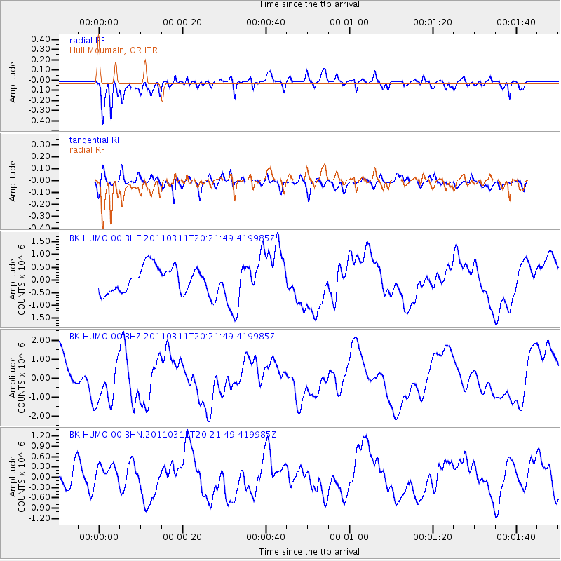
HUMO Hull Mountain, OR - Earthquake Result Viewer
*The percent match for this event was below the threshold and hence no stack was calculated.
| Earthquake location: |
Near East Coast Of Honshu, Japan |
| Earthquake latitude/longitude: |
39.0/142.6 |
| Earthquake time(UTC): |
2011/03/11 (070) 20:11:24 GMT |
| Earthquake Depth: |
17 km |
| Earthquake Magnitude: |
5.9 MB, 5.8 MS, 6.1 MW |
| Earthquake Catalog/Contributor: |
WHDF/NEIC |
|
| Network: |
BK Berkeley Digital Seismograph Network |
| Station: |
HUMO Hull Mountain, OR |
| Lat/Lon: |
42.61 N/122.96 W |
| Elevation: |
555 m |
|
| Distance: |
67.8 deg |
| Az: |
52.681 deg |
| Baz: |
302.932 deg |
| Ray Param: |
$rayparam |
*The percent match for this event was below the threshold and hence was not used in the summary stack. |
|
| Radial Match: |
69.25587 % |
| Radial Bump: |
400 |
| Transverse Match: |
61.47917 % |
| Transverse Bump: |
400 |
| SOD ConfigId: |
356183 |
| Insert Time: |
2011-08-18 10:11:25.256 +0000 |
| GWidth: |
2.5 |
| Max Bumps: |
400 |
| Tol: |
0.001 |
|
Signal To Noise
| Channel | StoN | STA | LTA |
| BK:HUMO:00:BHZ:20110311T20:21:49.419985Z | 1.0768524 | 1.1190186E-6 | 1.0391569E-6 |
| BK:HUMO:00:BHN:20110311T20:21:49.419985Z | 1.2110561 | 3.456084E-7 | 2.853777E-7 |
| BK:HUMO:00:BHE:20110311T20:21:49.419985Z | 2.0224922 | 9.885002E-7 | 4.887535E-7 |
| Arrivals |
| Ps | |
| PpPs | |
| PsPs/PpSs | |


