You are here: Home > Network List > CI - Caltech Regional Seismic Network Stations List
> Station LRL Laurel Mtn Radio Fac, Ridgecrest, CA, USA > Earthquake Result Viewer
LRL Laurel Mtn Radio Fac, Ridgecrest, CA, USA - Earthquake Result Viewer
*The percent match for this event was below the threshold and hence no stack was calculated.
| Earthquake location: |
Near East Coast Of Honshu, Japan |
| Earthquake latitude/longitude: |
39.0/142.6 |
| Earthquake time(UTC): |
2011/03/11 (070) 20:11:24 GMT |
| Earthquake Depth: |
17 km |
| Earthquake Magnitude: |
5.9 MB, 5.8 MS, 6.1 MW |
| Earthquake Catalog/Contributor: |
WHDF/NEIC |
|
| Network: |
CI Caltech Regional Seismic Network |
| Station: |
LRL Laurel Mtn Radio Fac, Ridgecrest, CA, USA |
| Lat/Lon: |
35.48 N/117.68 W |
| Elevation: |
1340 m |
|
| Distance: |
75.2 deg |
| Az: |
56.313 deg |
| Baz: |
307.406 deg |
| Ray Param: |
$rayparam |
*The percent match for this event was below the threshold and hence was not used in the summary stack. |
|
| Radial Match: |
60.53634 % |
| Radial Bump: |
384 |
| Transverse Match: |
39.325542 % |
| Transverse Bump: |
314 |
| SOD ConfigId: |
356183 |
| Insert Time: |
2011-08-18 10:14:12.849 +0000 |
| GWidth: |
2.5 |
| Max Bumps: |
400 |
| Tol: |
0.001 |
|
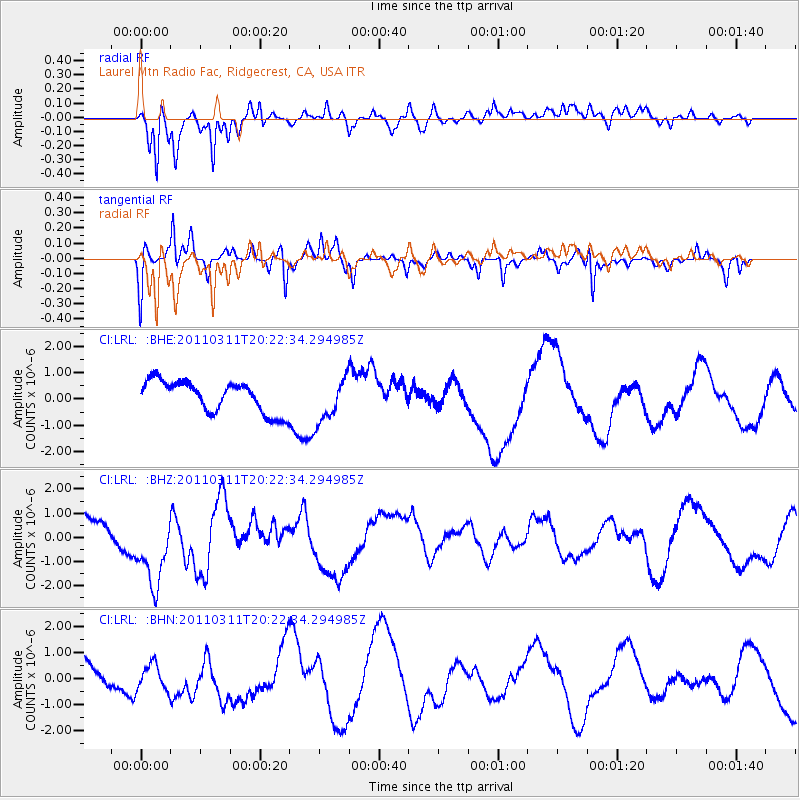
Signal To Noise
| Channel | StoN | STA | LTA |
| CI:LRL: :BHZ:20110311T20:22:34.294985Z | 3.7849298 | 1.7246747E-6 | 4.556689E-7 |
| CI:LRL: :BHN:20110311T20:22:34.294985Z | 0.7270798 | 4.846162E-7 | 6.6652404E-7 |
| CI:LRL: :BHE:20110311T20:22:34.294985Z | 1.409803 | 8.4073156E-7 | 5.963468E-7 |
| Arrivals |
| Ps | |
| PpPs | |
| PsPs/PpSs | |


