You are here: Home > Network List > TA - USArray Transportable Network (new EarthScope stations) Stations List
> Station R28A Tribune, KS, USA > Earthquake Result Viewer
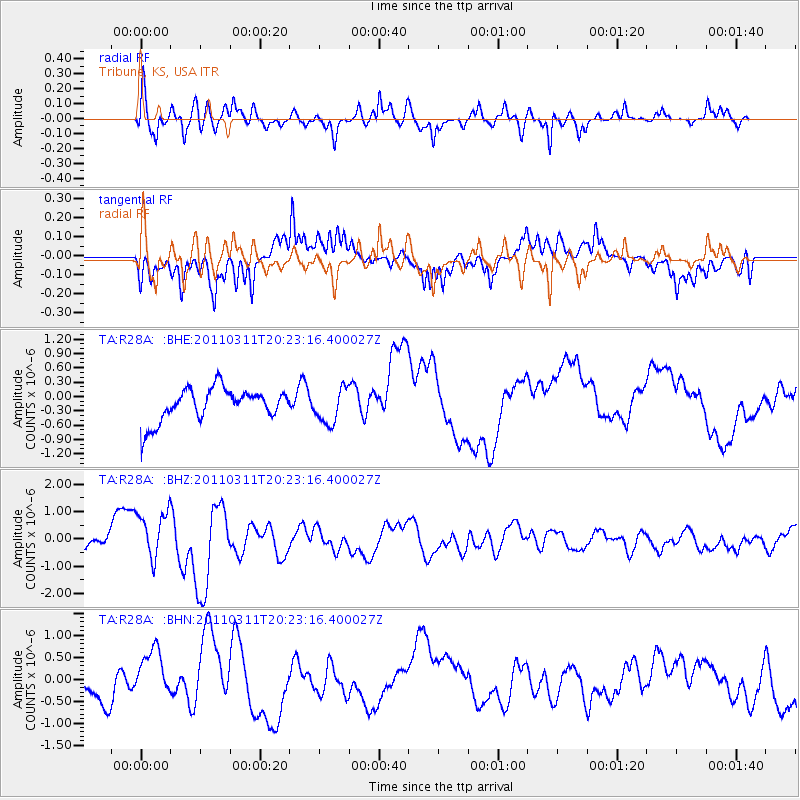
R28A Tribune, KS, USA - Earthquake Result Viewer
*The percent match for this event was below the threshold and hence no stack was calculated.
| Earthquake location: |
Near East Coast Of Honshu, Japan |
| Earthquake latitude/longitude: |
39.0/142.6 |
| Earthquake time(UTC): |
2011/03/11 (070) 20:11:24 GMT |
| Earthquake Depth: |
17 km |
| Earthquake Magnitude: |
5.9 MB, 5.8 MS, 6.1 MW |
| Earthquake Catalog/Contributor: |
WHDF/NEIC |
|
| Network: |
TA USArray Transportable Network (new EarthScope stations) |
| Station: |
R28A Tribune, KS, USA |
| Lat/Lon: |
38.34 N/101.81 W |
| Elevation: |
1108 m |
|
| Distance: |
82.9 deg |
| Az: |
45.629 deg |
| Baz: |
314.904 deg |
| Ray Param: |
$rayparam |
*The percent match for this event was below the threshold and hence was not used in the summary stack. |
|
| Radial Match: |
72.759766 % |
| Radial Bump: |
400 |
| Transverse Match: |
62.905464 % |
| Transverse Bump: |
361 |
| SOD ConfigId: |
356183 |
| Insert Time: |
2011-08-18 11:07:54.121 +0000 |
| GWidth: |
2.5 |
| Max Bumps: |
400 |
| Tol: |
0.001 |
|
Signal To Noise
| Channel | StoN | STA | LTA |
| TA:R28A: :BHZ:20110311T20:23:16.400027Z | 2.1897497 | 1.0079941E-6 | 4.603239E-7 |
| TA:R28A: :BHN:20110311T20:23:16.400027Z | 1.8679564 | 6.133992E-7 | 3.2837983E-7 |
| TA:R28A: :BHE:20110311T20:23:16.400027Z | 1.0661256 | 3.6483854E-7 | 3.422097E-7 |
| Arrivals |
| Ps | |
| PpPs | |
| PsPs/PpSs | |


