You are here: Home > Network List > TA - USArray Transportable Network (new EarthScope stations) Stations List
> Station H25A Fruitdale, SD, USA > Earthquake Result Viewer
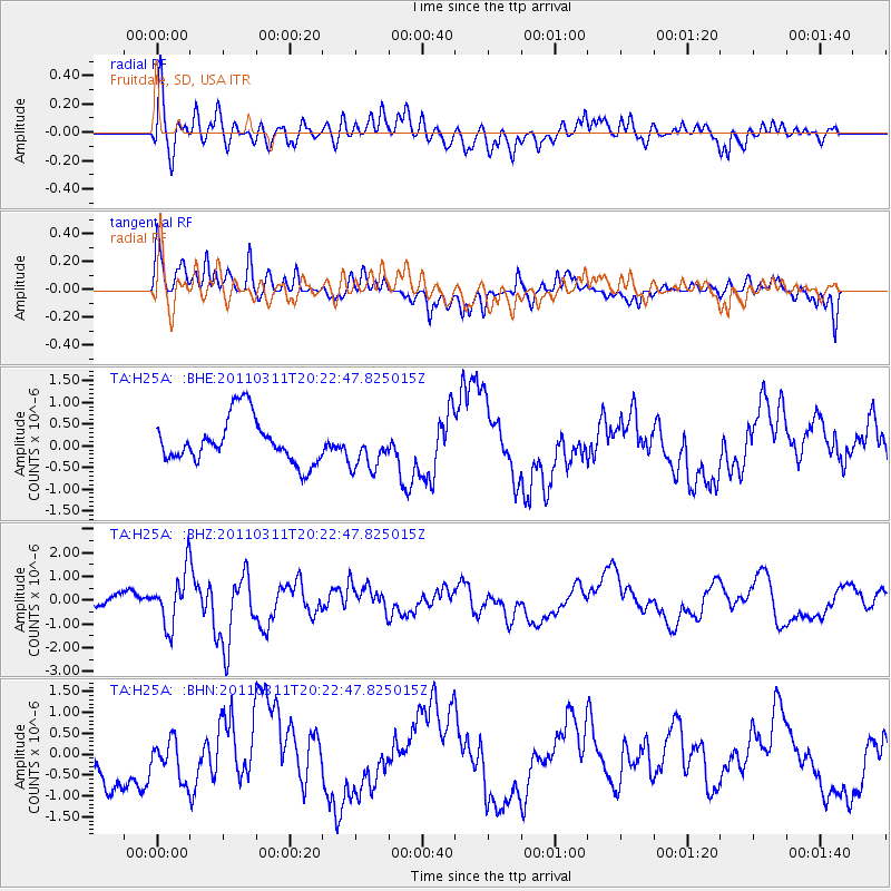
H25A Fruitdale, SD, USA - Earthquake Result Viewer
*The percent match for this event was below the threshold and hence no stack was calculated.
| Earthquake location: |
Near East Coast Of Honshu, Japan |
| Earthquake latitude/longitude: |
39.0/142.6 |
| Earthquake time(UTC): |
2011/03/11 (070) 20:11:24 GMT |
| Earthquake Depth: |
17 km |
| Earthquake Magnitude: |
5.9 MB, 5.8 MS, 6.1 MW |
| Earthquake Catalog/Contributor: |
WHDF/NEIC |
|
| Network: |
TA USArray Transportable Network (new EarthScope stations) |
| Station: |
H25A Fruitdale, SD, USA |
| Lat/Lon: |
44.62 N/103.60 W |
| Elevation: |
942 m |
|
| Distance: |
77.6 deg |
| Az: |
42.0 deg |
| Baz: |
313.108 deg |
| Ray Param: |
$rayparam |
*The percent match for this event was below the threshold and hence was not used in the summary stack. |
|
| Radial Match: |
73.03218 % |
| Radial Bump: |
400 |
| Transverse Match: |
27.308546 % |
| Transverse Bump: |
366 |
| SOD ConfigId: |
356183 |
| Insert Time: |
2011-08-18 11:25:17.110 +0000 |
| GWidth: |
2.5 |
| Max Bumps: |
400 |
| Tol: |
0.001 |
|
Signal To Noise
| Channel | StoN | STA | LTA |
| TA:H25A: :BHZ:20110311T20:22:47.825015Z | 4.5268645 | 1.1131716E-6 | 2.4590344E-7 |
| TA:H25A: :BHN:20110311T20:22:47.825015Z | 0.71674544 | 4.869317E-7 | 6.793649E-7 |
| TA:H25A: :BHE:20110311T20:22:47.825015Z | 0.9212172 | 4.781492E-7 | 5.1904067E-7 |
| Arrivals |
| Ps | |
| PpPs | |
| PsPs/PpSs | |


