You are here: Home > Network List > TA - USArray Transportable Network (new EarthScope stations) Stations List
> Station C37A Embarrass, MN, USA > Earthquake Result Viewer
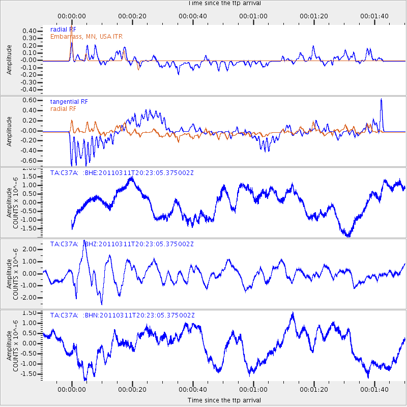
C37A Embarrass, MN, USA - Earthquake Result Viewer
*The percent match for this event was below the threshold and hence no stack was calculated.
| Earthquake location: |
Near East Coast Of Honshu, Japan |
| Earthquake latitude/longitude: |
39.0/142.6 |
| Earthquake time(UTC): |
2011/03/11 (070) 20:11:24 GMT |
| Earthquake Depth: |
17 km |
| Earthquake Magnitude: |
5.9 MB, 5.8 MS, 6.1 MW |
| Earthquake Catalog/Contributor: |
WHDF/NEIC |
|
| Network: |
TA USArray Transportable Network (new EarthScope stations) |
| Station: |
C37A Embarrass, MN, USA |
| Lat/Lon: |
47.73 N/92.19 W |
| Elevation: |
447 m |
|
| Distance: |
80.8 deg |
| Az: |
33.982 deg |
| Baz: |
319.829 deg |
| Ray Param: |
$rayparam |
*The percent match for this event was below the threshold and hence was not used in the summary stack. |
|
| Radial Match: |
51.203228 % |
| Radial Bump: |
400 |
| Transverse Match: |
67.02842 % |
| Transverse Bump: |
400 |
| SOD ConfigId: |
356183 |
| Insert Time: |
2011-08-18 12:26:44.924 +0000 |
| GWidth: |
2.5 |
| Max Bumps: |
400 |
| Tol: |
0.001 |
|
Signal To Noise
| Channel | StoN | STA | LTA |
| TA:C37A: :BHZ:20110311T20:23:05.375002Z | 4.6845374 | 1.3656569E-6 | 2.915244E-7 |
| TA:C37A: :BHN:20110311T20:23:05.375002Z | 3.8425424 | 1.2405856E-6 | 3.2285539E-7 |
| TA:C37A: :BHE:20110311T20:23:05.375002Z | 1.4568722 | 9.090557E-7 | 6.2397766E-7 |
| Arrivals |
| Ps | |
| PpPs | |
| PsPs/PpSs | |


