You are here: Home > Network List > IU - Global Seismograph Network (GSN - IRIS/USGS) Stations List
> Station CCM Cathedral Cave, Missouri, USA > Earthquake Result Viewer
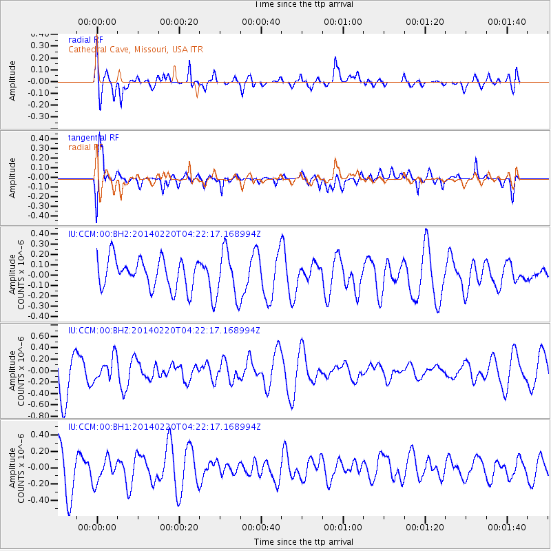
CCM Cathedral Cave, Missouri, USA - Earthquake Result Viewer
*The percent match for this event was below the threshold and hence no stack was calculated.
| Earthquake location: |
Southern Mid-Atlantic Ridge |
| Earthquake latitude/longitude: |
-14.1/-14.6 |
| Earthquake time(UTC): |
2014/02/20 (051) 04:09:57 GMT |
| Earthquake Depth: |
14 km |
| Earthquake Magnitude: |
5.1 MW |
| Earthquake Catalog/Contributor: |
ISC/ISC |
|
| Network: |
IU Global Seismograph Network (GSN - IRIS/USGS) |
| Station: |
CCM Cathedral Cave, Missouri, USA |
| Lat/Lon: |
38.06 N/91.24 W |
| Elevation: |
222 m |
|
| Distance: |
88.4 deg |
| Az: |
309.79 deg |
| Baz: |
109.226 deg |
| Ray Param: |
$rayparam |
*The percent match for this event was below the threshold and hence was not used in the summary stack. |
|
| Radial Match: |
60.163246 % |
| Radial Bump: |
400 |
| Transverse Match: |
58.388035 % |
| Transverse Bump: |
400 |
| SOD ConfigId: |
3390531 |
| Insert Time: |
2019-04-10 09:45:53.761 +0000 |
| GWidth: |
2.5 |
| Max Bumps: |
400 |
| Tol: |
0.001 |
|
Signal To Noise
| Channel | StoN | STA | LTA |
| IU:CCM:00:BHZ:20140220T04:22:17.168994Z | 0.563471 | 2.0623749E-7 | 3.6601259E-7 |
| IU:CCM:00:BH1:20140220T04:22:17.168994Z | 0.47791642 | 1.5341705E-7 | 3.210123E-7 |
| IU:CCM:00:BH2:20140220T04:22:17.168994Z | 1.6194559 | 2.2859642E-7 | 1.411563E-7 |
| Arrivals |
| Ps | |
| PpPs | |
| PsPs/PpSs | |


